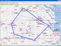
My task over the next few days is to do the planning. Husband is going with us as a back-seat observer, so the weight and balance will be different from what I'm used to.
I'm going to try to figure out the circular slide-rule flight computer (wowzah) to do it the old way, and of course use an electronic system to do it in a more efficient way (probably AOPA's Real-Time Flight Planner). Of course I'll use ForeFlight to check weather the night before and the morning of the flight.
The route will basically be:
- JGG to the Richmond (RIC) VOR, overfly RIC
- Gordonsville (GVL) VOR up the V38 Victor airway to Charlottesville (CHO), home of Dave Matthews
- Land at CHO (a towered airport), taxi and takeoff
- Head down to Lynchburg (LYH), land, refuel and stretch
- Get to Halifax (RZZ) or another southern-middleish airport, and either land/taxi/takeoff or just overfly
- Back home
If we do go to Halifax, there's a nice big lake south of Lynchburg that would be pretty cool to use for a pilotage leg.

A preliminary throw-it-in-to-get-a-baseline routing in AOPA/RTFP says that's 327 miles, 3 hours 9 minutes, and 29 gallons of fuel. We're aiming for 3 hours of flight time, and the plane holds 38 gallons.
The western part of this route is on the Cincinnati sectional; the rest is on the familiar Washington sectional.
I'll post more as I get into the details...
Hey there,
ReplyDeleteThat route is going to take you around some nice scenery so I want to see lots of pictures ;)
That is of course after ground speed checks and computing new ETA's :) The main point is to enjoy the view.
Cheers
FD
It does look like a scenic trip, and Husband will be in the back with the handheld GPS, the digital camera and a video camera!
ReplyDeleteWicked,
ReplyDeleteCan't wait to see the photo's !
Cheers,
FD