Goals:
- First cross-country trip (x-c).
- Use pilotage, navaids and dead reckoning (DR) to get from point a to point b.
- Talk to ATC, approach, and use flight following.
Flight:
Things were running long and busy at work this morning, so I didn't have time to update my nav log for the actual winds that would be a factor in the day's flight legs. I felt really crappy about that, but I had the AOPA RTFP wind-adjusted course printouts, so that would have to do. I can get practice with the wind side of the E6B over the next few days... I'm sure that will be a blast.
Preflight briefing was longer than usual, as you might expect. We met at the terminal and went into the closet that doubles as a pilot pre-flight area where there's a phone, deskspace and a computer for checking the weather. (There are lots of other open spaces to sit and go over charts and whatnot, but not with computer and phone nearby.) We went over the route I had planned and checked a few pieces of information. I didn't think to print out the flight plan form, which kind of screwed us in the end because we couldn't print it from the office computer. Luckily, Chuck had one in the car.
So I called 1-800-WX-BRIEF for the first time. The guy was super nice when I told him I was a student filing my first VFR flight plan. I'm sure he'd have been super nice anyway. We had already filled out the form by hand so it would be ready. Two things threw me/him off: (1) He asked for aircraft type and I said "transponder." On the form I had, the choices were transponder or DME. He asked if it was something-alpha. I told him I didn't know, and he asked whether we had a transponder and could report altimeter, and Chuck whispered also to tell him specifically no DME. I still am not sure what that means yet, but the AIM will probably tell me when I get home. (2) I gave him my name and started to give him my address, but he stopped me and asked for the home-base FBO phone number instead. Finally, he told me to call Leesburg to open it when I was ready, which we estimated to be at ~1830Z (1:30 ET).
We got down to the airplane and found Husband sitting in the backseat. He was going with us, and it was great to see him there. I wasn't nervous about anything at this point (got it all out of my system while staring at the ceiling from 2-5 this morning), so I guess it's just that I like seeing him. :)
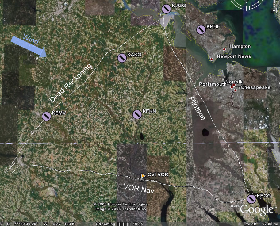
The plan was to go JGG to ECG by pilotage at 3500', opening the flight plan with Leesburg just after takeoff and talking to Norfolk Approach to pick up flight following. From ECG to RZZ would be a 4500' leg using the CVI VOR for navigation. Finally, from RZZ to JGG would be dead reckoning at 3500', using EMV and AKQ as checkpoints to break the ~65 nm leg into thirds.
We looked at the POH to get an idea of takeoff performance at our weight of ~2150 lbs. It would take longer than usual, but I didn't find it to be alarming or anything. We left from 31 and hooked around south, staying well west of the nuclear station. I called up Leesburg and opened the flight plan. My brief chat with him should have been much briefer, but it was my first time and the task was accomplished. Then I tried to get Norfolk on the air, and it took several tries, although the first try doesn't really count because I was still on the Leesburg frequency! Dumb! Eventually I did get him and we were in the system.
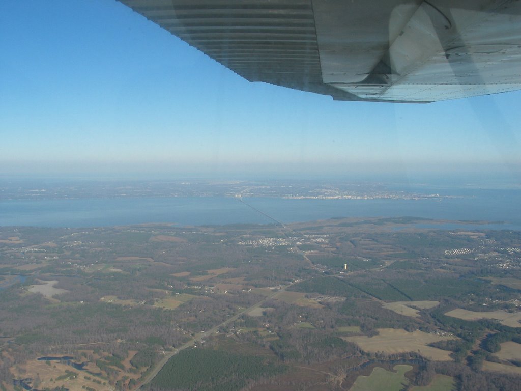 The James River Bridge (I think) crossing, duh, the James River!
One of the landmarks for pilotage on this leg was Lake Drummond. From 3500' on a semi-hazy day, it's big enough and was catching the sun enough to look like a glowing disc in the middle of a gray-green swatch. Nice and easy to pick out. Just east of that lake was a long straight road with a long straight canal right next to it; another good landmark. We'd fly parallel to it for a short while, then we'd be able to see the inlet that, if followed, would lead us down to ECG. And indeed it did.
As we got close to ECG (which, by the way, is Elizabeth City Coast Guard station), we were handed off to the tower. A very good-natured guy answered, and I was happy to be interacting with such a positive personality for my first time into a towered field! He told us to set up for right traffic for 28 and to report midfield on downwind. I still had some altitude to lose, so Chuck suggested I tell him we wanted to do a 360 to bleed some off. He approved and said to report when reestablished in the pattern. You can see from the image of the track that we did that over the water, which was neat and a little disconcerting at the same time!
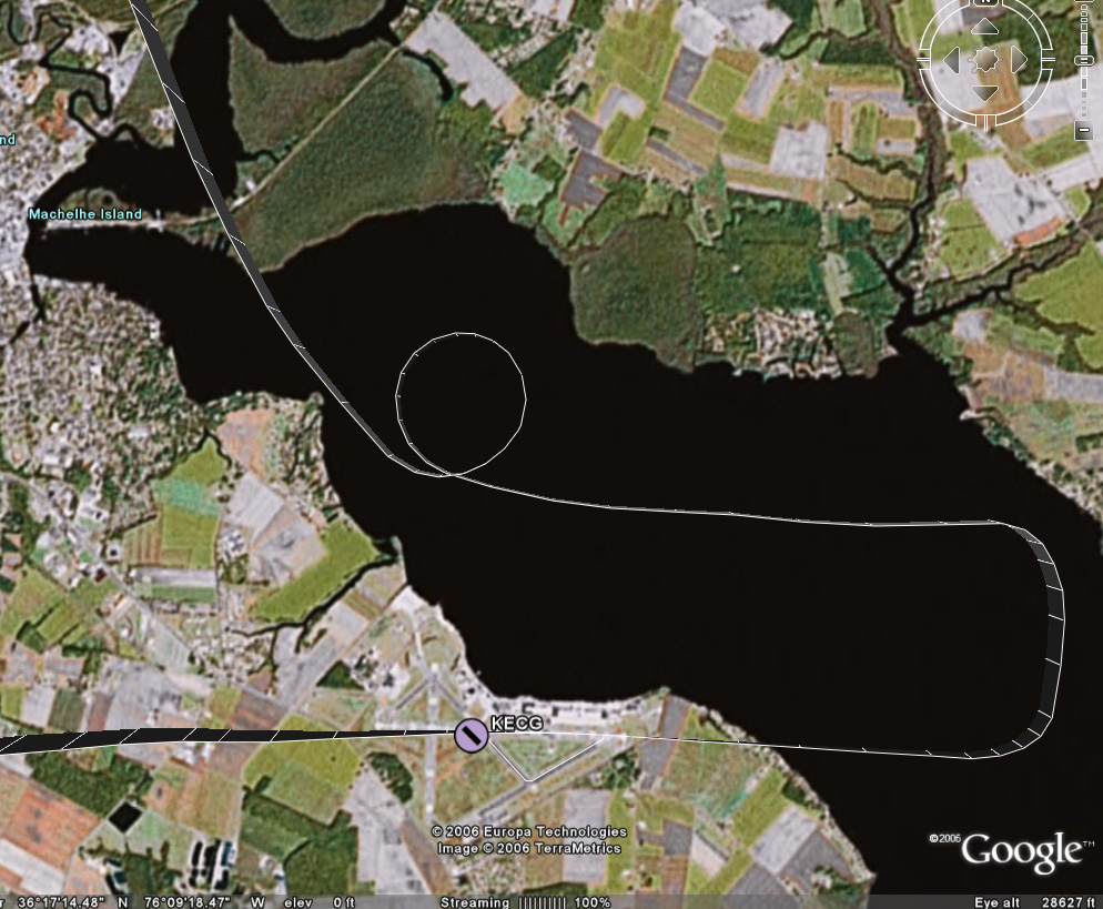 Anyway, we got back into the pattern and -- this was neat -- he said he'd tell me when to turn base. Well, ok then. I'd have to be a little more off-the-cuff with setting up to land, since the normal cues for putting out flaps or slowing down would be out of my control. It ended up being quite odd, though, because we had a very long downwind (extended well past the approach end of 28) before he told us to turn in. It was for the sake of ground operations: a jet and a 4-prop C130 were taxiing across the field. I reported to him when we were on final, and he cleared us to land. (Note: The GPS points say it was actually only a 2.5-mile final, but it seemed a lot longer than that! Final at JGG was less than 1 mile, and final at RZZ was a little over a mile.
And about an hour and a half we did! Just kidding, but that final was so long it seemed like we'd never get there. I had to power back up somewhat to keep from losing too much altitude along this stretch (so that 360 wouldn't have been necessary, had we known this was coming). But we made it to the runway and had a decent touchdown.
 Mr. Nice Controller instructed me to turn off at taxiway Charlie, then hook a right and the FBO would be straight ahead. I replied that we'd like to taxi back and depart, and so he told us to take a left off taxiway Charlie instead and hold short for 28. I cleaned up the plane and took that left and followed a C130 to the hold short line, giving him (and his clouds of exhaust) puh-lenty of room. They took off and a short bit later we were cleared to depart straight out, which we did without event.
We compared landmarks to the sectional to decide when we were clear of his airspace and then I radioed to tell him that and thanks. He approved a frequency change and that was the end of that. I dialed in CVI, dialed in the 290 radial and then jockeyed around a little to get on it. The trip to it was uneventful as the flying goes, save for a little waddling around as I lost and then realigned the heading. Mentally, though, it was a little flustering. Chuck was asking me math questions, and I didn't think I was overloaded but I was having a hard time reasoning through. Eventually I started jotting things down on the kneeboard and was able to be more logical about it. It was stuff like "How long will it take us to get to RZZ?" That shouldn't be that hard -- I knew roughly where we were, could estimate from the highlighted path on the sectional how far we had to go, but for some reason when it came to figuring out how many minutes for that distance at our current ground speed (which the GPS gave me in knots), I just couldn't do it! I felt like a freakin moron and that was frustrating.
So I jotted down my little conversion factor -- ( 60 minutes/1 hour ) * ( 1 hour/98 nm ) * ( 42 nm left to go ) ---- so (60*42)/98. Riiiiight. I'm gonna do that in my head at the snap of the fingers. I was starting to multiply when Chuck changed it up and asked how many minutes it took to go one (nautical) mile.
If you have a dog, you know the dog reaction to something they just don't understand. Ears up, eyebrows up, head tilted to the side. That's how I felt.
Ok, minutes per mile. Back to the kneeboard. ( 60 minutes/1 hour ) * ( 1 hour/98 nm ) ---- so 60/98. So I previously had been figuring out just that conversion factor.... Ok, 60/98 is easily estimated to be around .67... So .67 minutes per mile, 42 miles left, 2/3 of 42 would be 28? Ok, 28 minutes to go.
Ugh. That was harder than it should have been. Looking at it, I think I would have been better off to think of 42/98 -- a little less than half -- and then take that portion of an hour.
So, whatever. I'll come back to this later.
A few minutes later another math problem: How far from the airport should we start our descent? Hmmm, oh, ok. We're at 4500', pattern altitude at the airport is ~1000'. So we've got 3500' to lose. Let's assume a nice gentle 500'/min descent. So we need 7 minutes. That one was easy enough.
Now what? What distance from the airport corresponds to 7 minutes? ( 98 nm / 1 hour ) * ( 1 hour / 60 minutes ) * 7 minutes ---- 98 * 7 / 60. I didn't get it in the air without some more leading questions from Chuck to break it down, but now when I look at it it seems easy -- 98/60 is roughly 1.5, time (round up to) 10 is 15. 15 miles out, plus a few miles to be near pattern altitude to check out the field and get settled in the environment. So at 18 miles out we'd start the descent.
Ok, fine. Except it didn't totally go like that. There was some other intermediate conversion factor in there, and I don't remember it specifically, but there was one on our final leg, so I'll think about it more in a few minutes...
The other thing that happened to fluster me a little was that during our discussion about how turbulent it was that day -- it was coming in waves where we'd have several minutes of nice calm air then several minutes of big bumps -- Chuck asked what we can do in the yellow arc on the airspeed indicator. The phrasing of the question threw me off. The yellow arc (on ours) goes from Vsse to Vne. I knew Vsse to be the "don't go faster than this in turbulent conditions" speed. But what can you do in that speed range? I don't know. The answer basically is that you can fly straight-and-level in the yellow arc. You don't want to stress the plane at those speeds, so you don't fly in that range when it's turbulent. You don't do maneuvers at those speeds.
When we started the descent, I was glad to be done with trying to maintain that radial from CVI to RZZ (again, you can see the squirreliness in the track). The sectional indicated that the airport was southwest of "stacks" on the edge of a town near the lake. I found the lake, found a town, and saw a plant of some sort that did have some vapor exhaust, so I started pointing to it, which was a little to the right of the nose. As we got closer, however, I realized that there was another town with two much taller stacks a little farther from the water. Consulting the sectional again showed that these taller stacks were the ones that led to the airport. I pointed back to the left a touch, and before long a nice clearing appeared with a long edge oriented the way we expected the runway to be. Sweet.
I called UNICOM, and a pleasant woman answered that we'd be using 23 and asked if she could get us a car or fuel or anything. Wasn't that nice? We wouldn't be needing anything, and so I swung wide to the southwest to get on a 45 for left downwind for 23. We had a decent, almost-perpendicular-to-the-runway crosswind at this point in the flight, and could see that the windsock down there was almost fully extended.
I started my usual pattern -- at 1000' for this airport -- abeam the numbers, and started to descend. I had overlooked that one little detail that this field's elevation is 200' higher than home, and for roughly equivalent pattern altitudes something would obviously need to change. Well, obvious to Chuck and obvious to me after he pointed it out. I powered up to stop the descent, and had also been planning on a higher airspeed over the threshold, so this was ok. As I turned final, directly into the blazing lowering sun, I was at ~500' over the field, had two notches of flaps out, and was doing the constant-correction technique. I crabbed a little, and then I decided to slip a little, and kept aligned with the right edge of the runway (the wind was from the right). I had another decent touchdown, but as I started to brake and the nose came down, the nosewheel started shimmying like it wanted to come off!
I pulled back on the yoke as far as I could with one hand, trying to get the weight shifted back to the main wheels and the shimmying to stop. Chuck hopped on to help me pull back farther, and it did stop. As we slowed and the nose rotated down, it started again. This time I jumped on it with both hands and got it under control myself. (On Wednesday (after this x-c which was on Tuesday), Husband met with the mechanic for a few different issues, and they pulled the nosewheel shimmy dampener and found that the seals had dried out and there was no hydraulic fluid left. Mechanic was supposed to fix it that day, I think.)
We taxiied back to the approach end of 23 (which I incorrectly and generically called the end of 5) and took off into that inconveniently located sun. We departed and rose to ~1200' before turning off to the left and following the pattern as we continued to climb. As we left the airport I checked my nav log for the DR "settings" for the first checkpoint and set us up. We headed out and continued climbing to 3500'.
I really fought to keep on the heading for this exercise, knowing that being off by a degree would have a bigger impact the farther I went. Granted, each checkpoint was only 16-18 miles apart, but still... Much to my astonishment, we were dead on for EMV as far as heading goes, and were only about 20 seconds late in getting there. (Since RTFP doesn't build in time for the climb out of RZZ, that seemed pretty good o me.) Enthused, I reconfigured us for the next checkpoint.
This time, I was bad. We were on course and I was holding the heading pretty well. I even had it trimmed well enough that when Chuck said to let the plane fly itself (no autopilot, remember), it held 3500 nicely and except for the occasional bobble from the wind it stayed true. What was bad, though, is that as the time for AKQ was drawing near, I started cheating. AKQ is hard to find, and if we weren't dead on I wanted to be prepared for whatever correction would be needed. The only thing that helps to find it from 10 miles out is that it's just north of a little town in the middle of woods and farmland. I saw a town, and I even thought I could make out the white radar dome. So I nudged our nose just slightly to the left to point us toward the town. That was bad, and I learned my lesson. My eyes fooled me, and that wasn't the right town. As we got even closer, I couldn't find a runway, so I glanced down at the GPS -- we were several miles west of the airport! In looking at the GPS track above, you can see where I nudged left going up to AKQ, and how if I had just stayed the course we would have been really close.
From there I could see the curves in the river that cradle JGG so we just went by pilotage the rest of the way. Somewhere along this last jaunt we talked about how next time we'll use the E6B wind wheel to make adjustments on the fly (ha ha ha, that pun never gets old), and then came the last piece of math.
The part of this math that stands out in my mind was that 102 - 60 is 42 and 42/6 is 7 so we have 1.7 of something... minutes or miles and where did that 6 come from? 102 was our groundspeed at the time, so that would be 1.7 miles per minute. I've tried that with a few other numbers and it's a math trick -- find an even number of times it'll divide (in our case 1, but think about something like 330/50, where it would be 6). Take the remainder (42 or 30) and divide by the original divisor divided by 10 (6 or 5), then put it together with a decimal and you'll get your answer (1.7 or 6.6). Ah, yes, introducing the decimal justifies dividing by 10. This obviously works nicely for divisors that are multiples of 10. Now why were we figuring that out? Oh, well, if we were deciding when to descend, we'd know how long it would require to get down, so this factor would tell us how far from the airport we'd need to be when we started the descent.
The landing at JGG was normal with the exception of another nosewheel shimmy. I was nowhere near as tired as I expected to be.
(Don't make fun of my gum-chewing! It helps me to fly better, I swear! And you can see just how bad the sun was at RZZ.)
Discussion:
- ATC, approach, etc: I haven't really figured out the flow for these interactions yet. What helped me to get a grip of the various emergency procedures was to understand the flow -- for instance, in flight engine loss goes preserve altitude, figure out where to go, try to restart, communicate, shutdown. That's a logical sequence of events, and each of those items has a set of tasks associated with it.
I figure there'll be some nice flow for talking to ATC. Something like hail them, give location and intention, respond as appropriate. But when talking to approach maybe it's different, more like hail them, give intention, respond as required. Getting an understanding of that will make it easier to fill in the details. And with experience hopefully it won't seem like a random and blubbery chat every time.... - Dead reckoning: So this is the kind of navigation that I've talked about with Husband and said repeatedly that I just don't see how it could work. It seems like there are so many factors, and so many things that could change between when you do your calculations and two hours later when you get in the air and two hours after that when you get to the later checkpoints. But I'll be damned if RZZ to EMV wasn't perfect empirical evidence that it does in fact work. And I'll also be damned if EMV to AKQ wasn't perfect empirical evidence of screwing up what would have worked by thinking I knew better than the calculations. I mean, you've gotta be heads-up and flexible and ready to adjust your plan, right? But I misjudged and proved that changing the plan without a good solid indisputable reason produced the wrong results.
- Math: I'm an engineer. I don't hate math. I assume that (1) just like the whole can't-do-math thing from one of the first lessons, after I'm used to the various things that are going on during a cross-country it'll come easier and (2) after I've done those kinds of calculations a few more times and am familiar with what I'm trying to determine and how best to get it it'll come easier.
The workload thing (#1) is a cop-out explanation, though, since it wasn't like I had to do math while listening to a controller or something; the math came at times when it was just normal flight. - Husband: Husband said he was proud of me and my progress and he'll have no problem whatsoever letting me do everything on the next trip. The previous trips I've done everything in-flight, but no takeoffs or landings. Plus, next Monday he's going to do his BFR with Chuck, and do it from the right seat.
- Tracking a heading: My goodness. When we were in the air, I knew I was doing a little meandering and realigning on the heading, but I didn't think it was nearly as bad as what the GPS track shows! Is that amount of divergence normal, or a sign of inexperience, or a sign of too little focus on heading, or what? On the one hand, I'm being pretty hard on myself about being sloppy, but on the other hand, I'd have had to spend twice as much time looking at the heading indicator and cross-checking the mag compass for accuracy to have stuck it better. I'm guessing there's a reasonable balance there. I also wonder whether a less turbulent day would have made a difference -- there was a sigmet for moderate turbulence, and the ECG-RZZ leg did have a fair amount of bumps, but does turbulence affect the heading-tracking ability much?
Self-Assessment: More polish, more practice, especially on the com!
- Flying
- Preflight, taxiing, normal takeoff, short-field takeoff: Good.
- Soft-field takeoff: Needs practice.
- Maintaining airspeed, stalls, slow flight (VR/IR), maintain/change attitude/altitude/heading by instruments: Good.
- Recover attitude, altitude, heading by instruments: Acceptable.
- Forced landing: Good, need more practice.
- Forward slip:: Dunno, needs more practice.
- Pattern, normal landing, directional control after landing: Good.
- Crosswind landing: Decent.
- Radio work: Untowered, good; everything else, needs focused practice!
- Short-field landing: Improved.
- Soft-field landing: Not sure...
- Navigating
- ADF: Okay for an intro, needs practice.
- VOR: Use of is good; tracking the heading needs refinement.
- Dead reckoning: Gotta trust the numbers! Also we'll practice adjusting the numbers in-flight for differing circumstances next time.
Next: I've got the plane Monday afternoon for another x-c, assuming Chuck is up for it after Husband's BFR.
- More cross-country planning (with just-prior wind calcs!).
- Short cross-country trip.
Hours logged total: 29.8
Instrument hours logged this lesson: 0.0
Instrument Hours logged total: 1.6
Take-offs and landings this flight: 3
Take-offs and landings total: 80
PIC hours total:: 5.7
Congrats!!! Great job!!!
ReplyDelete