Monday, December 18, 2006

Solo 10: Towered airport

Goals:
  • Land at a towered airport (PHF) solo.

Flight:
To help assuage some of my gooberness about planning, I decided during lunch at 11:30 that I'd go for a quick flight, just to land at PHF for the first time by myself and come back. PHF is 12 nm away, so it ought to be quite doable without much planning since this is my local area and also without missing too much work. (Husband (a.k.a., my Boss) is out of the office today for a business meeting, so shhh... don't tell him I was playing hookie!) I had gone home for lunch, so as I left I grabbed the sectional (which was out this morning for my continued planning of the Wednesday x-c) and threw my flight bag in the back seat.

I popped back into the office to check for TFRs and do a check of the weather on the way to the airport. The PHF TAF put the winds at 9 kts for the next 2 hours, mostly down the runway at both JGG and PHFj, and the JGG METAR was showing 5 kts at the moment. Well, not much for crosswind practice, but within my endorsed limits. No TFRs, no relevant NOTAMs. Cool. Aside from returning to the office after making it halfway to the airport because of the realization that I didn't have the PHF plate or airport diagram, everything went as normal through engine crank.

At engine crank, I realized that I hadn't removed the chocks. Crud. Inconvenient for being alone. Mixture to idle-cutoff, hop out, remove chocks, hop in, go through the whole pre-crank checklist again just to be sure... Ok, good to go.

So I dialed in the AWOS. 290@12. Hmmm. My logbook endorsement says up to 10 kt crosswind component, but doesn't say max wind; the older endorsement was a limit of 10 kt winds with 5 kt x/w. 12 kts at 290 means way more headwind than crosswind for departure from 31, so I figured it would be ok but was still hesitant. While I was trying to make up my mind, the AWOS loop started again, and a new report came out just then that said 290@10. Well that was no problem no matter how you looked at it.

Taxi, short-field takeoff, departure to the west to avoid the school, then north to skirt the FAF Class D and fly down the peninsula to PHF. A plane inbound for JGG asked me for location info as I was reaching my cruise altitude of 2500', and I responded with that and a location 5 nm north of the field moving east. Once I found I-64, I followed it southeast toward PHF. Staying on the northern side of I-64 would keep me clear of FAF the whole way down.

At 8 miles out, I dialed in the ATIS and got information Papa; winds at 8 kts with runways 25 and 20 in use. At 7 miles out, I called the Newport News Tower and I think made a good contact, saying that I was at 2500' 7 miles northwest of the field inbound for landing with information Papa. The lady controller told me to set up for a straight-in approach for 20 and report a 2-mile final.

Hmmmmm... I haven't done a straight-in approach before, and given my crappy skills at judging distances, I was a little unsure about doing my procedures for airspeed reduction and flaps and whatnot. Plus, if the descent here was as bumpy as the ascent from JGG, I could expect to be busy with wing-levelling tasks, too. Since 20 is 6500' long, I resolved to feel it out and err on the high side.

Using the GPS to tell me when I was at 2 miles out, I called to report that, then put out 10 degrees of flaps and began descending from 1000'. I didn't hear anything for a little while, and when I got down to 500' and hadn't been cleared to land yet, I prepared to call and remind her that I was getting there. Before I could do that, however, she called and cleared someone else to land on 25 and told me I was #2 for landing on 25.

Whoa. Wait. What?!?!!?!

I immediately called and said that I was on short final for 20 and please advise. She said to do a right 360 for spacing. Aw, crap. 85 mph, 10 degrees of flaps, 400'. I got really nervous. Here goes.... Power in, carb heat in, slight right bank to avoid the runway (was that necessary?), level, speed up, leave flaps alone, climb and turn. And there was the turbulence. Dammit. As I got to ~270 degrees of the turn and had searched unsuccessfully for this other traffic, I called again and asked the tower to confirm that I was supposed to land 20. She confirmed 20 and said I was cleared to land. I guess that either she misspoke earlier or I misheard, but if that was the case it surely wasn't for lack of listening!

I repeated the clearance and struggled to get back toward centerline after having overshot it dramatically coming out of the 360. I was recentered with plenty of short-final to spare, and put out another notch of flaps to get down. Just as I was about to touch down, a gust grabbed me and pushed my right wing up. I tried to level with the ailerons and preserve a straight-ahead track with rudder, and mere split seconds later touched down. The nosewheel was pointed off to the right, so to the right 388 went. I straightened it out quickly and came to a stop as soon as possible.

Ugh. I guess she was letting someone land on 25 and giving them time to be safely down without threatening my runway before clearing me to land.

Now I didn't know what to do. I hadn't looked up the answer to my question from Friday's lesson: Can I turn off the runway at a towered airport on any taxiway I like? Well, I figured that doing nothing until instructed was better than possibly breaking the rules, so I called the tower, told her I was a student and requested instructions.

The lady controller, who had been nice and patient with me so far, continued being nice and patient but started talking reaaaallllllyyyy ssslloooooowwwwllly. I will try my best never to have to tell them I'm a student again (I will if I need to, but this was torture!). I had stopped just short of taxiway Delta, and she said, nice and slow and clear, "Take the taxiway to your right." Oh I just sank a little. She didn't even call it by its name, she just gave me the most fundamental -- and nearly impossible to screw up -- directions. I replied that I'd take taxiway Delta, then cleared the runway.

As I was rolling off the runway, she called again.

NNT: "November 388, where would you like to go?"
388: "388 would like to taxi for departure to the west back to Williamsburg."
NNT: "November 388, take taxiway Alpha for Runway 20."
388: "Taxiway Alpha for 20 for 388."

Then I sat there for a moment to clean up the plane, as I typically do right after clearing the runway. After maybe 15 seconds, she called again.

NNT: "November 388, taxiway Alpha is to your right."

Oh come on! I could see the signs, I had my taxiway diagram, I knew what to do, I just needed a sec to finish up my checklist! There were no other planes landing or in the pattern, and it wouldn't have made any sense for any departing planes to come through my little taxi spot, so I don't think she was hurrying me... Oh to be branded a student! :)

388: "Roger, 388 will take taxiway Alpha to 20."

By then I was done with the cleanup, so I throttled up and headed up to 20. I positioned myself in place behind the hold-short line for 20 and did the departure checklist before calling the tower.

388: "NNT, 388 is holding short of 20 and is ready for departure."
NNT: "November 388, hold short for traffic."
388: "388 is holding short."

During this time, a Gulfstream landed on 25 and taxied across to Rick Aviation. He was on Delta when he called the tower. (I don't remember his tail number so I'll call him GS.)

GS: "NNT, GS, understand cleared to cross 20."
NNT: "GS, affirmative."

Then a few seconds later...

GS: "NNT, GS, be advised that your wind advisories may be wrong if you're using the midfield windsock. A red hawk has been sitting on the sock since we came in."
NNT: "Oooh, pretty."

Argh.

NNT: "November 388, cleared for departure, runway 20."
388: "388 is cleared for departure, runway 20."

And away I went. Actually kinda glad to be leaving that whole experience behind. As I got out over the river, I called the tower and advised that I was leaving her airspace. She approved a frequency change, I repeated and g'day'ed her.

On the sectional I located the FAF CTAF and decided I'd do the same as Chuck and I had done last Friday by advising that we'd transition the area above their airspace. I plugged it into the standby position, swapped the frequencies and announced:

388: "Felker Tower, Skyhawk 35388 is departing Newport News airspace en route to Williamsburg and will overfly your airspace at 2700' over the dead fleet, Felker."
NNT: "November 35388, NNT, check frequencies, frequency change approved."

Urgh. I imagine she released her mike and muttered to a coworker, "Stupid student."

388: "Thanks, and my apologies."

I looked at the radio and sure enough, I had NNT's frequency of 118.7 in BOTH positions on the com. How'd that happen? I checked the sectional again, and that was the problem -- I had misread it. PHF's info is directly under the FAF airspace, and the FAF info is below and farther to the left.

With the correct frequency dialed in, I repeated the advisory to Fort Eustis (Felker).

FAF: "Aircraft calling Felker, repeat callsign."
388: "35388."
FAF: "35388, repeat altitude."
388: "Two thousand, seven hundred."
FAF: "35388, you are above my airspace. If you need traffic advisories contact Norfolk approach."
388: "Roger, thanks."

This guy sounded peeved that I had bothered him. There was nothing else going on on the frequency, but whatever. Maybe he was doing something else, and yeah, it wasn't necessary for me to call him. Whatever.

Up near the bend in the river, I started to descend, and looked around to see where I'd go if the engine had trouble. Very few choices: Power station to the left with lines crossing most of the fields; Army land to the right that I'd use if it really was an emergency but really would rather not; river and woods ahead. From 2700', perhaps I would have made the Colonial Parkway area, but the wind was out of the west and that wasn't good. A fun time at Fort Eustis it would have to be... should it be needed.

Luckily the engine didn't fail. I dialed in the JGG AWOS and it said winds 270@8 with max gusts of 15. Oh crap. That's not what I want to hear. Me no likey gusts. A little anxious, I continued to descend over the water to about 1200', and listened to the AWOS again. It had changed, and now was saying 270@8, no gusts. Well, ok, but I was still apprehensive as I turned onto the 45 for left downwind for 31. The pattern was mostly normal, with the exception of crabbing on downwind to avoid being pushed into the airport. I anticipated a shorter base, and so chose to extend my final a little to be sure I'd have time to set flaps and slow down. That part of the planning worked out well. I was a little hot coming over the threshold, and so floated a bit and then bounced once, but the wrestling I was doing with that wind had the majority of my attention.

I can't help but be reminded of my first solo. I don't think I've flown in gusty conditions since then. And I still don't like it.

Discussion:
  1. Talkie talkie: I feel really good about talking to the tower. Yes, it was painful once she started treating me like a student, but the parts leading up to that were good. When in doubt, I asked for confirmation. When the unexpected was happening, I piped up and requested advice. Other than the frequency change fiasco upon departing PHF, it really went well.

    In retrospect I am actually laughing at how she was talking to me. Whenever possible and safe I will avoid disclosing my status in the future!

  2. Straight-in approach: Needs practice, obviously. I'll have to figure out or learn from someone how a "normal" straight-in approach is executed.

  3. The value of planning: I didn't plan, deliberately, beyond having the basics. Check TFRs, wx, NOTAMs. Take a sectional. On the way over, though, in thinking about the flight, I knew I'd want the PHF plate and taxiway diagram. Ok, turn around and get them. If I had spent 5 minutes planning that flight, I would also have made my customary note card with the frequencies I'd be using, and would probably have avoided the PHF/FAF mix-up, although fundamentally that was nothing more than a mistake; still, one that could have been avoided. It was fine, I had everything I needed, but my normal anal preflight planning would have made it more organized. Shame on me.

  4. Judgment: Do you think I made the right call based on the winds AWOS reported before I left the parking spot?

    (1) I'll have to ask Chuck so I'm entirely clear on just what the logbook endorsement means, but I believe that going up did conform to the endorsement; the AWOS report at departure time was 290@10, well under the 10 kt x/w limit.

    (2) Moments before the AWOS report was different, and it was questionable whether it exceeded my legal allowable limits. Despite the fact that the current report was within limits, should I have considered that another change, potentially for the worse, could happen before I got back to land at JGG?

    (3) What if that inbound-for-JGG report of 15-kt gusts had continued until I was ready to land? Should I have diverted to West Point or back to PHF? Would I expect it to be any better at those locations? I bet I could pick up their AWOS/ATIS from the air around JGG, but what if I couldn't? I know there's such a thing as Flight Watch, but how would I talk to them and would this be a reasonable thing to call about? Even though the AWOS report did improve by the time I was near the pattern, it had obviously continued changing since I departed and would it continue to change over the next few minutes during my approach?


Self-Assessment: Talking with ATC was decent; not verbose, good inclusion of information, good reactions. I feel good about that. Most everything else on the day, though, I don't feel good about.
    Flying
  • Preflight, taxiing, normal/short-field/soft-field takeoff: Good.
  • Maintaining airspeed, stalls, slow flight (VR/IR), maintain/change attitude/altitude/heading by instruments: Good.
  • Recover attitude, altitude, heading by instruments: Acceptable.
  • Forced landing: Good, need more practice.
  • Forward slip:: Dunno, needs more practice.
  • Pattern, normal landing, directional control after landing: Good.
  • Radio work: Ok, needs practice.
  • Crosswind landing: Improved.
  • Short-field/soft-field landing: Improved.
    Navigating
  • ADF: Okay for an intro, needs practice.
  • VOR: Needs practice.

Next: Wednesday, 10 am, solo x-c.
  • Talk with FSS and use flight-following.
  • Practicing everything.
Hours logged this flight: 1.0
Hours logged total: 31.9
Instrument hours logged this lesson: 0
Instrument Hours logged total: 1.3
Take-offs and landings this flight: 2
Take-offs and landings total: 86 (this number seems wrong... must check logbook)
PIC hours total:: 8.8

Sunday, December 17, 2006

Just call me crUZA

Oh that was bad. That's my mother's sense of humor coming out.

Husband has decreed that I'll be the "acting" PIC (without of course being PIC since I'm just a lowly student) on the trip to SC, destination airport KUZA. I get the left seat, and he's going to be the "pilot not flying" and will do as much or as little as I ask him to do.

I am going to plan this trip. I had said previously that I wasn't going to, but I am. I just got to thinking that it would be a massive opportunity to miss if I don't. KUZA is just on the other side of Charlotte, outside of Bravo airspace but under one of the layers of its inverted wedding cake. It requires us to skirt parts of the airspace a little and make sure we are low enough at various points to be clear. I know Husband talked to CLT last time we went, but I don't know whether it was actually required, since we weren't coming into it; maybe it was just because flight-following handed us off. Other than that, it's 2+ hours of straight and level.

Reading about talking

I've said it before and I'll say it again -- I can't imagine doing primary training without living with a pilot!

One of the books in the reading room, I noticed the other night, is Say again, please. I set it on my bathroom counter so I'd see it in the morning, after work, in the evening... and wouldn't forget to start reading it. The book is about using the radio. It's about why we talk to each other and to controllers. It's about the information that's needed and relevant for different exchanges. It has examples for everything.

I read the first four chapters last night. So far it's easy to get through, but it is dense. There's no way I'll retain it all right now, but at least it's something practical I can add to the studying going on right now. Well, I haven't picked up my groundschool textbook in probably two weeks; it's getting to be like the kid who has to sit at the table until he finishes his green beans, sulking, checking out the curtains, memorizing the pattern on the ceiling plaster... Okay, it's not that bad yet, but I look at the book sitting there and even scrubbing the floors seems more appealing. It's just that it is sooo dry and a lot of it is "pass the knowledge exam" kind of reading, not stuff that's practical to my flights right now. Like Class A airspace boundaries and requirements. Or turbochargers.

I almost always have several books going at once, but I've been trying to discipline myself to get through the groundschool, not allowing any leisure reading until the textbook is done. This way, I'm still learning stuff that's relevant to my training, and it's very refreshing to have a book in the rotation now that's instructional but not painful to pick up. We'll see how that changes after a few more chapters. I'm into the chapters that are broken down by airspace, starting with G and moving backwards in the alphabet. When it gets to Alpha, and maybe even Bravo, we'll see how rapt it keeps me... :)

Anyway, several of you out there in interwebland have noted that I'm anal to the point of getting too keyed up. Yes, that's who I am about this training stuff. (That's not who I am with most other things, oddly.) Husband is being gracious enough to practice exchanges with me. Chuck and I hung around on the ground for a little while after the flight where I got the endorsement for landing solo at PHF to practice some different scenarios that might come up in talking with them, and also the importance of receiving and repeating clearances before enacting them. All of this prep makes me less anxious about going out and doing it. I don't care if I say something stupid, I'm used to looking like an idiot, but I don't want to say something or say it at the wrong time such that it causes problems for the controllers or other pilots.

And Husband's bookshelf is full of stuff that I'm sure is worth reading. There are a few Rod Machado books, Stick and Rudder, his instrument training books (not that I'll be cracking those babies open in the near future), leisure reading like The Cannibal Queen and Bandits over Baghdad, ... There are enough options there to enliven the reading rotation without feeling guilty, although I am going to have to crack down soon, finish up the studying and get the knowledge test out of the way.

Plus, I'm crossing my fingers for a few fiction books for Christmas, so the attention may further be divided...

Saturday, December 16, 2006

No solo x-c today

I had planned to do my first solo x-c today.

I spent several hours last night planning it out. It seemed like a good length (~156 nm) with good waypoints and interesting navigation paths (like using VOR fixes to route between Class C airspace and an MOA). Stuff I'd learn from but not be overwhelmed by.

At about 8:30, a wave of exhaustion just swept over me, and I could hardly keep my eyes open to finish the nav log. I wrapped it up, emailed the plan to Chuck, and went to bed.

But I couldn't sleep. At first it was just the usual thing where my brain wasn't done planning and still wanted to think through things. The plan was to meet at 9:00 at the JGG terminal to review, then I'd go at 10. That meant I'd need to get up ~7:30 to have a leisurely morning. But we were out of breakfast foods, so I'd have to go by Starbucks or something like that. And I wanted some snacks to take with me, because I'd rather fly the route and not have to find lunch along the way, so I'd need to go to the grocery store or a convenience store on the way. And then there was the matter of not having scrutinized the sectional for alternate airports in the case of a problem, so I'd need to get up extra early to find and print the appropriate diagrams.

It was turning into one thing after another, and before long I was getting worked up in a bad way. My heartbeat was too fast, my gut had that clenched-yet-hollow feeling. I kept telling myself it was stupid, that there'd be time for everything, that if something did go wrong I'd have to GPSs, etc. But it was no use, and I just didn't get much sleep.

At 6:30 I finally gave up and got up. I emailed Chuck to let him know that I was in no shape to fly and was postponing the x-c. It sucks, because it's gorgeous around here today -- mid-60s, cloudless, light winds...

Around that time I had come to the conclusion that the route was too aggressive for my first x-c. I still haven't totally ruled that out, but I think the real fundamental problem is that I don't feel prepared for that route for all the reasons mentioned above. I'll try to take a look at it again this afternoon and maybe it'll feel better.

Then again, I'm soooo sleepy!

Friday, December 15, 2006

Two new airports

Goals:
  • More practice at a towered airport.
  • Get signed off for solo landings at AKQ and PHF.

Flight:
Today I rode in the back during Husband's BFR -- he did a good job, and it was neat, but I'll leave the details to his post. One point of advice: look ahead, not out the side window, when someone is doing Dutch rolls.

After that, Chuck and I went up to make sure I could find and land at AKQ and PHF (towered) so's to add two more airports to my 25-nm limitation. We departed 31 and left out to 247, as was indicated by my DR calculations. I climbed to 2500', where the winds were supposed to be 250@26 (according to RTFP at 7:45 this morning for a 10 am departure, and it was now 10:30). I was expecting a measly groundspeed of 78 kts going down to AKQ, and the GPS was showing 90+. I used power and trim to get to an IAS of 117 mph, which is what the numbers in the nav log were based on.

Then Chuck had me use the E6B to do some figuring. Outside temp at 2500' was 10C, so I plugged that in. Next, to determine true airspeed (TAS), you find calibrated airspeed (CAS), for which we substituted IAS, on the wheel and read off the corresponding TAS. I left my notes on this in the car, so I'm not sure exactly what that came out to -- something like 119 kts. So, 119 kts with a nearly direct headwind of 26 kts means a ground speed of 93 kts. So my time value would be wrong, and if it was more than a 15 minute leg, we would have reworked the numbers.

But the angle was wrong, too. I don't know whether it was (1) the wind wasn't where it had been predicted to be 3 hours earlier or (2) the headings coming out of RTFP in fact are correct and I'm doing something fundamentally wrong in my by-hand calculations; my 247 took us well west of the field, west of Waverly even.

So when I knew for certain (based on landmarks) that we were going to be passing the field off to the side, we did a VOR check. I had determined before leaving that the ORF (to) 105 and FKN (to) 190 VOR radials intersect right over the field. So we turned to a heading of 090, knowing we were south of the 105 radial and headed back east. I then tuned in FKN and waited for the needle to center. We could see the airport just out the right side of the plane, and I switched our lonely single VOR indicator back to ORF to cross check and it was close.

Great. Good enough for government work. Next I was cleared by Chuck to land at AKQ. I had already dialed in the ASOS and it said the winds were variable and the altimeter setting was a full in-hg higher than JGG. As we fley just past the approach end of 20 while messing with the VORs, I could see the wind cone favoring 20 at that time. I flew away from the airport while I descended, then turned to the right to get on a 45 for left downwind for 20.

With a 9-kt wind at my back, I deliberately turned base early, crabbed along, and had a relatively short final that took a relatively long time! It wasn't one of my better landings recently -- the strong direct headwind and slooow progression of things threw me off a little, and so I flared to early and just waited seemingly forever for the plane to settle onto the runway, and that settle happened from a few inches higher than would be termed graceful, so it was more of a plop. No bounce, a little shimmy, but it was ok.

I back-taxied and we departed 20, then turned northeast to head toward Aberdeen and PHF. Along the way we discussed initiating contact with PHF, what to use as a reference when giving our location, etc. I checked ATIS and received information Mike; PHF was landing 20 (6000', the usual GA runway) and 25 (8000', for commercial and military traffic) today. The ghost fleet a few miles up-river is flagged on the sectional for use as a VFR landmark when talking to controllers, and I probably should have used that but I used Aberdeen anyway. Coming in over Aberdeen guaranteed clearance of Fort Eustis' airspace.

I hailed him at ~9 miles south of the field over Aberdeen, inbound for landing. He instructed me to set up for left traffic on 25 -- the runway nearer to us -- and report midfield downwind. He also added the wind and altimeter info; dang it, I forgot to tell him that I had info Mike. We heard him talking to a helicopter that was working 20, instructing him to stay north of (taxiway) delta, the taxiway along 25 on the 20 side. Landing on 25 would be neat; I tried to imagine what that huge of a runway was going to feel like in our dot of a plane but couldn't, despite having landed there in 172s with Husband many times in the past!

Crossing the river, PHF stands out pretty well. It's the huge V-shaped clearing! As we neared the airport, I turned right to get onto downwind, and just before I reached midfield the controller, who must have been bored this day, contacted me first and said I was cleared to land on 25 and hold short of 20 (7500' down the runway!). I repeated the clearance, then pointed out to Chuck that I had been given a LAHSO, in which student pilots aren't allowed to participate. He said it would be ok since he was there, but when I come back by myself to either announce when I make contact that I'm a student so they won't issue it or to decline it if it is issued.

When the controller had called me with the landing clearance, he referred to me as "November eight eight." That caught me off guard, and I didn't respond immediately. I had a good inkling that he was talking to me since the helicopter's ID sounded nothing like mine and there was no one else he'd be clearing right now for 25, let alone on the frequency at all. He called back again, and this time I responded by accepting the clearance for 35388 (just to be sure he meant me).

On base I felt I was doing good and Chuck said, "Well there's a reason to keep a high pattern!" I quickly scanned to see what he was talking about and didn't see anything. Then he pointed out that we were flying over power lines, probably not more than 200' below us, if that much. I turned final and wondered briefly where I'd be expected to turn off the runway, and therefore where I should aim to touch down. I decided that the numbers, as usual, were prudent, and if necessary I could speed right along down the runway.

It was pretty neat to go in there. It's hugemongous! I think the landing went well, but I don't really remember it very well. Had it not been for the nosewheel shimmy, I could have made the early taxiway turnoff. Instead, as I rolled past it, the controller told me to take Golf (the next one) and switch to ground. I repeated that, and Chuck suggested that for that instruction I should abbreviate it to "388, wilco." For a busy airport, it would make a difference for the airway clutter.

That does lead me to wonder whether, had I slowed enough to make that first turn off, could I have taken it or must I only exit the runway when/where instructed to do so?

I cleared the runway, cleaned up the plane and switched to ground. I called them and asked to taxi back for departure, and should have but didn't tell him where I was. I should have said, "Newport News ground, Skyhawk 35388 on Golf, request taxi for departure." Given the slow day, I'm sure he knew where I was, since I wasn't a helicopter in the air at the time, and he told me to take delta back to 25. He also called me Cherokee. Doesn't sound much like Skyhawk, but given the lack of traffic and the fact that any assumptions that might be made about Cherokee v. Skyhawk for that runway or my departure would probably be okay, I just taxied away.

The engine seemed a little rough to me during the taxi, and when Husband had started up this morning it was behaving oddly (carb ice), so I elected to do another run-up. It went fine.

I hailed the tower and told him I was ready to depart. He asked how I wanted to depart. To save a round on the radio, I could have initially said, "Newport News tower, Skyhawk 35388 is ready to depart, would like to depart VFR straight out." He cleared me to depart 25, and I went back simply with "Roger for 388." This earned me a correction from Chuck. Always, always fully repeat clearances to land and clearances to take off. Period. Other stuff can be abbreviated or not repeated, but clearances are a must.

Taking off from PHF was even more interesting than landing. I could see the end of the runway for most of the takeoff! It was great. I felt like a tiny little bug. Just before we reached the river, the controller came on with "Frequency change approved." I had already determined where I would call him to say I was beyond his airspace, but he beat me to the punch on everything today (which was actually nice for me, since I'm still a little tentative about when to say what). I acknowledged and wished him a good day, then started the plan for getting to JGG.

Initially we were going to go back to the southern shore of the James and cut up on the west side of the power station, but thought it would be a good practice to overfly Fort Eustis airspace (which tops out at 2500', I think -- something around that) and talk to them. So I turned up-river and tuned them in. After listening to silence for a few seconds to be sure it was clear, I advised, "Felker tower, Skyhawk 35388 is overflying your airspace at 2600' over the dead fleet." This was not required, since I wasn't in their airspace, but Chuck called it a "good citizen" contact; if it was a busy tower, we'd leave them alone, but they didn't seem to have anything going on, judging by the calm freq and the fact that there were no military helicopters in sight.

Anyway, a nice lady came back with a "Good afternoon, 35388" and then followed with something like "proceed as described," then gave me the local weather info and advised that if I needed any assistance that I could call Norfolk approach. And she sounded like she was smiling, which made me smile, too :)

After that it was a bumpy final (direct left crosswind) with a left-of-center touchdown (the crosswind disappeared below the trees and I didn't anticipate that).

And now I have two more airports that I can go to all by myself, one of them towered!

Discussion:
  1. Talking through things: I was very talkative on this flight. Don't know why... But it was mainly me talking about what I was doing. Things like "I see the airport, time to start descending, check the mixture, turn on landing lights, gonna descend a little faster than usual so I'll pull the throttle out more..." and so forth. Chuck kinda laughed at the end of it and said to keep that up and to do it on the checkride for two reasons: (1) The examiner will know what I'm thinking and why I'm doing things without having to ask, and (2) the more I talk, the less the examiner can!

  2. Winds not as expected: I was surprised at how far from my expectations the winds were when we got up there. That took me aback and I got a little worried; my planning went out the window (not literally). The groundspeed issue can be worked out, and while it was unsettling to have to think about reworking those numbers and dividing attention between the E6B and the traffic scan for the amount of time it would take to redo it all, it would be doable. Wind direction, however, I don't know that I could assess very well. Well, I suppose that if I used the groundspeed indication on the GPS, I could change my heading until it was the slowest, and that would be a full headwind, right? Other than that, how do you know?


Self-Assessment: .
    Flying
  • Preflight, taxiing, normal/short-field/soft-field takeoff: Good.
  • Maintaining airspeed, stalls, slow flight (VR/IR), maintain/change attitude/altitude/heading by instruments: Good.
  • Recover attitude, altitude, heading by instruments: Acceptable.
  • Forced landing: Good, need more practice.
  • Forward slip:: Dunno, needs more practice.
  • Pattern, normal landing, directional control after landing: Good.
  • Radio work: Needs practice.
  • Crosswind landing: Improved.
  • Short-field/soft-field landing: Improved.
    Navigating
  • ADF: Okay for an intro, needs practice.
  • VOR: Needs practice.

Next: Wednesday at 10 am I've got the plane reserved for the solo x-c.
  • Radio.
  • Practicing everything.
Hours logged this flight: 1.5
Hours logged total: 31.4
Instrument hours logged this lesson: 0
Instrument Hours logged total: 1.3
Take-offs and landings this flight: 3
Take-offs and landings total: 87 (this number seems wrong... must check logbook)
PIC hours total:: 7.8

Wednesday, December 13, 2006

More weight and balance...

We're hoping to fly down south for Christmas to visit family. Christmas presents a twist: big payload of gifts, both going down and coming back! We'll have gifts for at least 12 people, and I've thought ahead and gotten mostly gift cards or light-weight items for folks. That's cool, and there'll be room in the baggage compartment and no worries on weight there -- it'll only add a few pounds at most.

Coming back, however.... I know one gift that Husband's getting will be weighty and possibly even an awkward size for the luggage area (do NOT ask me about it, Husband, I will divulge no other clues!). Same thing for one gift idea I gave Husband that I think he gave to his mother. Plus, the luggage area has a total weight limitation, too, of something like 120 or 150 lbs.

Anyway, two adults up front, 100-lb dog in the backseat, luggage and gifts in the luggage area, fuel. I'll have to play around with it sometime over the next few days to see how much goodies we can keep! ;)

Imposed limits

Today's flight was first restricted and then canceled due to limits imposed on the plane and us.

Weather
The easy one to explain is the cancellation -- the weather ultimately shut us down today, and also canceled the flight part of Husband's scheduled BFR. NOAA had very consistently been predicting 60% chance of rain from 10-2 today. This morning it was foggy. Not just foggy, but faw-awggy. But as with most fogs it cleared out by mid-morning. Husband was meeting Chuck at the airport at 11 to start the BFR, and he called on his way over to have me give one last check of the weather.

JGG's METARs actually showed VFR with clear skies (below 12000) and 10 sm vis. The skies were anything but clear today, but I don't know the difference visually between clouds at 5000' v. 15000' so that could have been correct. Across the river at AKQ, it was LIFR with overcast at 300'. PHF showed similar to JGG, and its TAF indicated clouds that would gradually descend and thicken between 11 and 6, becoming IFR later tonight.

As the morning went on, I was optimistically planning my afternoon lesson which would hopefully end with me being endorsed to land solo at AKQ and PHF (towered). Again I ran into the RTFP error in headings from JGG (grr), but gave another check of the weather at JGG, AKQ and PHF using ForeFlight. The latest JGG METAR, ~11:45 or so maybe, said IFR. From VFR to IFR in less than an hour. PHF was getting worse more quickly than the TAF predicted, too. I accepted at that time that the afternoon flight would most likely not happen, but finished up the nav log planning as though we'd go DR to each point.

So, the weather imposed its will upon the day's plans. Oh well.

Required Equipment
Huh. Losing that silly little ELT antenna yesterday kinda screwed us. FAR 91.207 says you gotta have an operable emergency locator transmitter. But subparagraph f3 says the plane can still be flown for training purposes within 50 nm of home base.

Ahhh.... At first when I read the FAR, I thought, "There go the x-c plans!" But indeed, that was too quick of a conclusion to draw. Yes, the JGG-->LVL-->PHF x-c I've been planning and reworking every day for different wind conditions would be out; LVL is 60-some miles away. But we could still do an x-c; I'd just have to get a little creative with it. So I took out the sectional and my plotter and made a big 50-nm circle around JGG. That includes EMV, ORF, RIC, W75, PTB, ... Quite a few airports, actually. So the next step was to see how I could cobble together a route to get a couple of 50+ nm legs. JGG-->W75-->FCI-->PHF would give me two legs over 50, plus PHF for the tower and W75 (Hummel) would be the shortest field I'd ever flown to. And we'd still be following the regs. Sweet!

(A replacement antenna was supposed to have come into JGG today for us. Hopefully it did and will be installed soon, because I asked and Chuck agreed that my developing nav skills are good enough to do a solo x-c!)

Monday, December 11, 2006

Solo 9: Slow flight, soft-fields

The move to the new blogger appears to have gone well... yay!

Goals:
  • Slow flight & maneuvers.
  • Power-off stall.
  • Soft-field takeoffs.
  • Soft-field landings.
  • Use of checklists.

Flight:
The x-c for today was canceled since Chuck is sick (get better!). I used the time to get in some solo work, after getting all wound up last night when reading through the PTS. Normal preflight -- complete with verification that the ELT antenna was there and secure. Soft-field takeoff on 13, followed by a climb and turn out to the west to go to the Chickahominy River to do maneuvers. I consulted the checklist for cruise flight, which included turning off the landing lights and setting the mixture and throttle for efficient flight.

As I approached the river and did a final scan before starting my clearing turns, I noticed a bright white Cessna at my 3 o'clock, same altitude, same heading. We could have been flying in formation. I can't guess at how close he was, nor where he came from. I couldn't see people or read the tail number. He was probably at least 3000' away -- I'm trying to picture what he'd look like if we were sitting on opposite ends of the JGG runway, and I think he was smaller (farther) than that. I pushed my talkie button and announced to Williamsburg traffic -- not really knowing how better to try to alert him to my presence -- that I was 6 miles west of the field at 2500' with traffic (white Cessna) in sight. I kept an eye on him, and after 10 seconds or so he started climbing. I was at the point where I wanted to turn up north to go along the river in the direction of West Point, so I turned left (away from the plane) to start a clearing turn, and when I turned back he was well to the west of my position and my heading was now perpendicular, so it was all good.

I slowed for slow flight and listened to the blasted stall horn for ages as I flew for several minutes straight, focusing on maintaining altitude exactly on 2500'. I then used the rudder to turn left and right, scanning as much as I could -- when the stall warning is going, paranoia pulls my eyes back to the altimeter first and then the airspeed indicator. Anyway, the turns were fine so it was time for a power off stall.

I pulled back. And climbed. And the stall warning squealed away. I pulled back more. And climbed more. And the stall warning squealed away. I wish I had looked at the airspeed indicator then. I pulled back more aggressively and it broke. Carb heat and throttle, nose below the horizon, airspeed up, nose up, and rest.

So at 2500' I pointed up to FYJ and pulled out the checklist again for the "before landing" section. We've talked about, at Chuck's suggestion, creating a new checklist for "approaching the destination." This checklist includes figuring out when to start the descent, tuning in AWOS/ATIS/whatever is available, contacting ATC if appropriate, etc. I dialed in AWOS and it reported calm winds. I then dialed in CTAF and listened for several minutes as I started my descent (for such a low-altitude local flight I didn't rehearse the descent calculations, but probably ought to). The before-landing checklist reminded me to put the mixture to rich and turn on my landing light. I've also been instructed by Husband in the GUMPS mantra, even though U and P don't really apply to 388.

No one was manning UNICOM, no other calls were coming over the frequency, and my scans of the air and the ground showed no activity. I decided to set up on 9 for a soft-field landing after overflying the field at ~1300' (pattern altitude is 824). The wind sock indeed looked limp and there was no sign of life down there. The first landing was fine, fine, just fine. I landed nose-high and kept some back pressure to keep the weight on the main wheels. After rolling a bit down the runway, I eased forward and there was no shimmy -- yay! Since no one else was around, I announced that I'd roll out to the approach end of 27 (again, I should have made reference to the runway I was on -- 9), turn around and immediately depart.

As I rolled I did as much cleaning of the plane as I could remember: flaps up (from full extension), carb heat cold. During the interminable roll I grabbed the checklist and chose not to do the other after-landing items, such as switching the altimeter to stdby and killing landing/nav lights. I was going to do another soft-field takeoff and therefore wouldn't be stopping at the beginning of the runway, so I put out the recommended 10 degrees of flaps, then began the turnaround as I announced my departure to remain in the pattern.

It went fine. It's a weird-feeling takeoff. Departing 27 I turned off to the left and stayed in the pattern. Paying attention to altitude, I set up for another soft-field landing. On final I had a nice, slow approach and the short final was shallow. I was afraid it was a little too shallow and so throttled up just a tad to be absolutely sure to not touch down before the threshold! It would have been fine without the extra throttle, but really I should have picked a touchdown spot farther down the runway since it's so long and that's such a long rollout.

But rollout I did for an immediate turnaround and another soft-field takeoff to remain in the pattern. Left turn onto crosswind, normal pattern, another soft-field landing (not as shallow this time), a nosewheel shimmy when I allowed the nose to rotate down followed immediately by an opposite rotation, then after slowing the roll another shifting of the weight forward (no shimmy), a long rollout and I pulled off the runway. At this point I turned on the cell phone to call Husband so he could meet me at the airport for some engine examination.

Cell phone off, soft-field takeoff, and heading home. JGG was right-hand traffic for 13 and a normal, albeit very breeze-buffeted, landing and another nosewheel shimmy.

Husband met me at the airport and we took the upper nose cowl off to have a look around (thanks, FD, for the suggestion!). If energy persists through the evening I'll try to post some about what I learned there, but for now we just have to mention the ELT antenna since its loss was part of this flight. That's right, it was missing when I got down. WTF? Where did that go? And what else is going to just fall off mid-flight? Bizarro. Long story short, training flights within 50 nm can be legally conducted (FAR 91.207f) without a working emergency locator transmitter -- I'm just going to assume that missing the antenna counts as an inoperative transmitter. So no x-c until that is replaced; the mechanic is ordering one for us but it won't be here until Wednesday. Another partner in 388 was scheduled to fly up to Atlantic City tomorrow, but he can't do that legally now.

Discussion:
  1. Checklists and natural reactions: Checklists are good. No need to justify that. Use of checklists is insanely important to the FAA examiner; just read the PTS if you need proof. I use checklists for preflight, cruise, before landing, after landing and for shutdown/secure. I bought a little maneuver book that effectively is a collection of checklists for each maneuver, from normal takeoffs to s-turns to stalls to short/field work to crosswind stuff to commercial maneuvers.... I've gone through and annotated the maneuvers I've been taught and will be expected to demonstrate with information relative to our plane; things like the POH recommends 10 degrees of flaps for the soft-field takeoff and accelerating in ground effect to 65 mph then climbing.

    I used the booklet checklist before taking off to review the short-field takeoff and landing procedures since that was to be the main focus. I did not use the booklet for slow-flight setup and maneuvers, nor for the stall and subsequent recovery. I am going to try to get into the habit of using it every time it's practical.

    For the stall, I knew what I needed to do for the recovery and it was a natural reaction. Usually when preparing for any maneuver -- especially stalls -- I'll walk through it mentally to be sure I've got the actions there at the tip of my brain. This time, though, I wasn't worried or nervous about being on the brink of the stall, and when it broke my hand was pushing in the carb heat and throttle before my eyes got down there and I don't think I lost much altitude at all. It was a reassuring stall.

    The bad part of it is that I wasn't at idle when I started to provoke the stall, and that's why I kept climbing instead of pitch-breaking. My checklist would have reminded me about that.

  2. Slowing for slow flight: Previously when slowing down for slow flight maneuvers, I've felt that I was juggling too many things: throttling back, keeping altitude, adjusting trim, maintaining heading, scanning, reducing airspeed, etc. Husband and I chatted about it over lunch and he conveyed his tactic as ignoring airspeed and reducing the number of instruments to monitor down to two: RPM and altimeter. It doesn't take much pitch for me to lose visual field out the front, so I have to periodically check the DG, too, but dropping the airspeed indicator helped a lot. I also felt that I did a much better job of maintaining altitude during slow flight (with power adjustments) compared to the usual graceful, slow, nose-high descent. And yes, that's the anti-descent power that I should have removed when transitioning to a stall.

  3. Soft-field takeoffs: They're just weird. It feels weird. Today I wasn't totally positive I was off the ground until I started to drift laterally over the runway. Well, FYJ is a little easier to assess because it's a much rougher runway. But it's just weird, unnatural. I'd like to try it at a real soft field sometime.

    Speaking of which, we had dinner recently with Gordon and Christine, the proprietors of Campbell Field on the Eastern Shore. It's a little grass strip across the bay from here, 42 nm. Perhaps we shall get some soft-field practice by going to one of their Soup on Sunday events.


Self-Assessment: Practice practice practice practice practice practice must ace checkride practice practice practice.
    Flying
  • Preflight, taxiing, normal/short-field/soft-field takeoff: Good.
  • Maintaining airspeed, stalls, slow flight (VR/IR), maintain/change attitude/altitude/heading by instruments: Good.
  • Recover attitude, altitude, heading by instruments: Acceptable.
  • Forced landing: Good, need more practice.
  • Forward slip:: Dunno, needs more practice.
  • Pattern, radio calls, normal landing, directional control after landing: Good.
  • Crosswind landing: Improved.
  • Short-field/soft-field landing: Improved.
    Navigating
  • ADF: Okay for an intro, needs practice.
  • VOR: Needs practice.

Next: Maybe on Wednesday if Chuck has recovered we'll get Husband's BFR and my x-c done.
  • Soft-field and short-field landings in succession to emphasize the differences (approach slope & speed).
  • Radio.
  • Practicing everything.
Hours logged this flight: 1.1
Hours logged total: 30.9
Instrument hours logged this lesson: 0
Instrument Hours logged total: 1.3
Take-offs and landings this flight: 4
Take-offs and landings total: 84 (this number seems wrong... must check logbook)
PIC hours total:: 7.8

Switching to the new blogger...

It's time to move over to the new blogger. Crossing fingers for a smooth transition...

No x-c today

Unfortunately, Chuck is sick today so no BFR for Husband and no x-c for me. I suppose that's another reason for reduced time aloft in winter -- more colds.

The afternoon is looking nice for some solo practice. I'll probably leave JGG, go to the practice area and do something, maybe slow flight maneuvers and a steep turn or something. But the main focus will be soft-field takeoffs and landings, and I'll use all airports that I'm allowed to use -- FYJ and JGG :)

Sunday, December 10, 2006

PTS -- eeeeeek!

I just read through the PTS.

My tummy went all butterflies.

I'm sooooo not ready.

I'm at 29.8 hours, 6.7 of them solo. I had been thinking I'd shoot to do my checkride in mid-January, but I just don't predict feeling ready then.

The thing is, I feel good about at the performance stuff. Well, S-turns I haven't really gotten to practice in any wind, but everything else, sure, I could probably do it all right now. And I've got as much time as I need to refine the soft-field takeoffs and landings and other aspects that need polish but that are fundamentally in place.

It's the knowledge stuff that is so intimidating. I can't remember the various details about the different classes of airspaces. I get class and category confused for aircraft when relating to pilot certification or aircraft certification (who came up with that dumb naming system?). I don't know how the electrical system works, or what I'd do if all of a sudden my avionics when kaput; the checklists only cover so much. (Ok, that last part is more practical than knowledge, but if never used it's still just knowledge, right?!?) And on and on...

And now I'm going to try to sleep, being all hopped up (in a good way) about tomorrow's x-c and all hopped up (in a bad way) about the checkride that's not even close to being scheduled!

Winds that help and hurt

I have planned the JGG-->LVL-->PHF x-c and have run through it twice with the wind conditions at the times of the exercises.

The no-wind flight time for the trip is 1:20. The first set of winds helped on one leg as much as they hurt on the other, and the wind-corrected speeds produced a trip time of 1:20. Neat! The winds today, however, were overall more beneficial and the trip time came down to 1:15.

The trip is a DR x-c since that's what I did the worst on during the last one. The waypoints on the way to LVL are the town of Waverly, with its collection of towers and pairing of highway and train tracks, and the town of Jarratt, next to I-95 with a water tower and a factory. On the way to PHF, the first checkpoint is a VOR fix between the LVL and FKN VORs, which ought to be neat since we have just the one VOR indicator. The second checkpoint is AKQ (and I'll resist the urge to cheat this time and will nail it!), then Aberdeen and then we should be on the horn with the PHF tower.

Oh, and I'm now positive that RTFP is wrong wrt JGG, for this x-c at least.

Saturday, December 09, 2006

Planning the next x-c, and suspicious RTFP data...

We're planning for a second x-c this Monday afternoon after Husband's BFR.

The route this time is JGG->LVL->PHF->JGG. The first leg is ~60 nm, and the second is ~66 nm. PHF is ~12 nm from JGG, but it's Class D so the aim is for me to be endorsed to fly there solo (and get more practice with a tower on my own time).

I intend to do the two long legs by DR since that's what I feel least comfortable with at this time and since it seems to me that it would be the most challenging nav method to "update" in-flight; during the last x-c, Chuck said to have my E6B in-hand on this upcoming flight and we'd do what-if scenarios for wind conditions that differ from what was expected.

Last night I sat down with the sectional and measured everything out and did all the calculations by hand for the no-wind situation. I then hopped on RTFP and compared to their results; again, it was similar* but RTFP's time was a little shorter (no landing at LVL, presumably). I then checked the weather along the route so I could do the wind corrections as though I was going to do that trip in the immediate future. ("similar*" means read the rest of this post...)

(There was a NOTAM for PHF saying: PHF 12/017 PHF 7/25 CLSD 0500-1100 DLY WEF 0612100500-0612171100. I'll have to figure that one out here shortly to see if it'll be a factor.)

I was dissatisfied again with RTFP on account of not being able to indicate different altitudes for different legs. I expect 4500 going to LVL and 3500 coming back to PHF. I decided to use 4000 for the exercise. The DUATS readout gave a bunch of information and I wasn't sure what to use; the winds-aloft/temperature table gave listings for ORF, RIC, RDU, etc but not for any place along the route. If I had to pick, I'd have chosen the RIC numbers since they're geographically the closest to LVL. Since I wasn't sure about this, I checked RTFP's nav log. The numbers it used for each leg didn't totally make sense to me. Here's what the table said:


FT30006000Interpolated for 4000Dist to JGGDist to LVLDist to PHF
ORF322234273323327720
RIC312234263223334945
RDU33203426332112972134
HAT332234263323???
EMI302932313129???


I don't know what HAT is -- perhaps KHSE at 132 nm from JGG on the NC Outer Banks? No idea about EMI (other than a VOR in MD), either.

RTFP used 310@22 for JGG-->LVL, same as RIC for 3000'. Why not the 4000' interpolation numbers? It used 328@23 for LVL-->PHF. Huh? Maybe that comes from seeing that (1) LVL is closer to RDU than ORF (but closest overall to RIC) and (2) PHF is 20 nm from ORF, so there are two votes for 330 and one for 320 -- settle on 328? Why not 327? Does it take distance into consideration? (77*33 + 49*32 + 72*33)/(77+49+72) => 327.5. Maybe that's why? What about the PHF side of the trip? (20*33 + 45*32)/65 => 323. Ehrn?

There *must* be a more sophisticated model in it for how it decides what to use. But let's go back to the by-hand method: a pilot with a sectional, a nav log and a DUATS brief isn't going to use a sophisticated model. From that table, what would I use?

That confusion aside, the point of the exercise was to use some winds to practice the calculations and learn to use the wind calculator, so I took RTFP's numbers. This would at least allow me to compare my results to theirs. And it was pretty easy. That wheel is easy to use and pretty slick.

But I did get results that made me even less confident in the information that RTFP gives me, and Husband and I compared this with Seattle Avionics' Voyager (the free version) for the same trip. Voyager agreed with my calculations. The problem, I think, is that RTFP didn't correct the heading out of JGG for magnetic variance (which is 10W here) -- the heading was 10 degrees less than what I thought it should be.. I had kinda noticed in the previous x-c that the corrected heading coming back to JGG was 10 degrees different from what I had expected, but I figured since it was my first time doing the grunt work that I had mis-measured or been sloppy with the wheel or some similar error.

I'm still reserving judgment since it's such a "stable" software package that I assume is widely used. 50 million Elvis fans can't be wrong, right? In that case, I must be doing something wrong. But then that means that Voyager is doing something wrong, too.

Could they have JGG in the wrong place? The instrument approach to JGG is the HCM VOR 188 radial. In RTFP if you make a direct route from HCM to JGG it says the heading is 192 (no weather downloaded). All of my other heading calculations between points -- Aberdeen-->ECG, ECG-->CVI, CVI-->RZZ, RZZ->EMV, EMV-->AKQ, LVL-->PHF -- have matched very closely to the RTFP results; it just seems to be an error with JGG, so far in my trials. But this sample size is pretty small...

I just don't know what to make of that yet.

Friday, December 08, 2006

Say it Right!

Just as I'm mired in my own thoughts about communicating with ATC and other airspace regulators, I get the AOPA ePilot newsletter with info about a new program called Say it Right!

That looks pretty useful, but what on earth do they have against the mid-atlantic? I guess maybe it's a pain to get people to fly into the DC area for a seminar, but they could come to Richmond or Norfolk or Raleigh or somewhere closer than PA or SC!

Side effects of flight training, part 2

We watched Star Wars Episode IV: A New Hope last night. Luke, Han and Chewie got sucked into the Death Star and after many ordeals finally rescued the Princess and made their way back to the "hangar" where the Falcon was being held, guarded by a bunch of storm troopers and with a bunch of generic evil maintenance guys going about and onto the ship.

Someone says something along the lines of "You think it'll fly?" since everyone is obviously wondering what the Empire did to it in their absence.

Han looks out into the bay and two seconds later says "Yeah."

To which I said, laughing, "What a thorough preflight!"

Ah, good times.

Tuesday, December 05, 2006

JEP FII-17: First X-C

[Updated: Corrected statistic at the bottom.]

Goals:
  • First cross-country trip (x-c).
  • Use pilotage, navaids and dead reckoning (DR) to get from point a to point b.
  • Talk to ATC, approach, and use flight following.

Flight:
Things were running long and busy at work this morning, so I didn't have time to update my nav log for the actual winds that would be a factor in the day's flight legs. I felt really crappy about that, but I had the AOPA RTFP wind-adjusted course printouts, so that would have to do. I can get practice with the wind side of the E6B over the next few days... I'm sure that will be a blast.

Preflight briefing was longer than usual, as you might expect. We met at the terminal and went into the closet that doubles as a pilot pre-flight area where there's a phone, deskspace and a computer for checking the weather. (There are lots of other open spaces to sit and go over charts and whatnot, but not with computer and phone nearby.) We went over the route I had planned and checked a few pieces of information. I didn't think to print out the flight plan form, which kind of screwed us in the end because we couldn't print it from the office computer. Luckily, Chuck had one in the car.

So I called 1-800-WX-BRIEF for the first time. The guy was super nice when I told him I was a student filing my first VFR flight plan. I'm sure he'd have been super nice anyway. We had already filled out the form by hand so it would be ready. Two things threw me/him off: (1) He asked for aircraft type and I said "transponder." On the form I had, the choices were transponder or DME. He asked if it was something-alpha. I told him I didn't know, and he asked whether we had a transponder and could report altimeter, and Chuck whispered also to tell him specifically no DME. I still am not sure what that means yet, but the AIM will probably tell me when I get home. (2) I gave him my name and started to give him my address, but he stopped me and asked for the home-base FBO phone number instead. Finally, he told me to call Leesburg to open it when I was ready, which we estimated to be at ~1830Z (1:30 ET).

We got down to the airplane and found Husband sitting in the backseat. He was going with us, and it was great to see him there. I wasn't nervous about anything at this point (got it all out of my system while staring at the ceiling from 2-5 this morning), so I guess it's just that I like seeing him. :)

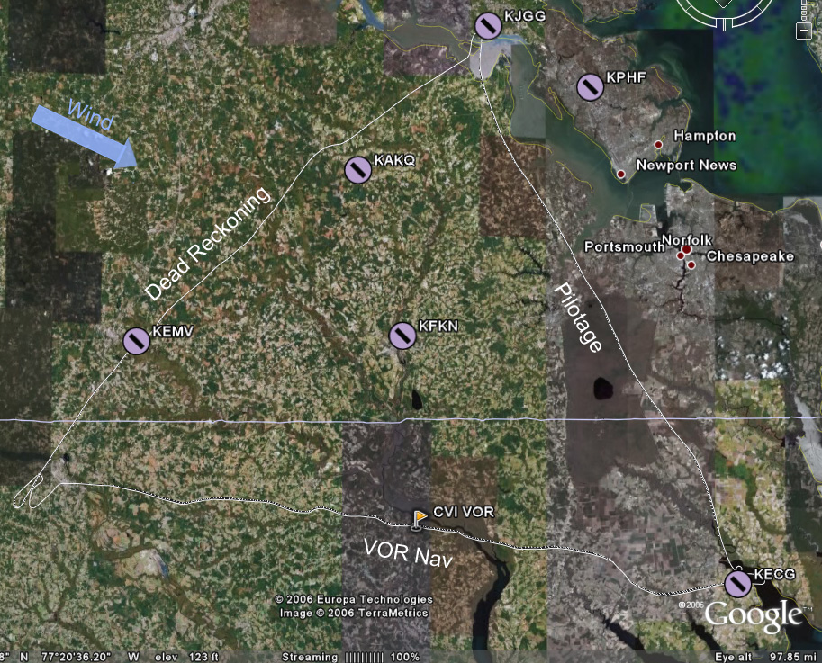
The plan was to go JGG to ECG by pilotage at 3500', opening the flight plan with Leesburg just after takeoff and talking to Norfolk Approach to pick up flight following. From ECG to RZZ would be a 4500' leg using the CVI VOR for navigation. Finally, from RZZ to JGG would be dead reckoning at 3500', using EMV and AKQ as checkpoints to break the ~65 nm leg into thirds.


We looked at the POH to get an idea of takeoff performance at our weight of ~2150 lbs. It would take longer than usual, but I didn't find it to be alarming or anything. We left from 31 and hooked around south, staying well west of the nuclear station. I called up Leesburg and opened the flight plan. My brief chat with him should have been much briefer, but it was my first time and the task was accomplished. Then I tried to get Norfolk on the air, and it took several tries, although the first try doesn't really count because I was still on the Leesburg frequency! Dumb! Eventually I did get him and we were in the system.

The James River Bridge (I think) crossing, duh, the James River!


One of the landmarks for pilotage on this leg was Lake Drummond. From 3500' on a semi-hazy day, it's big enough and was catching the sun enough to look like a glowing disc in the middle of a gray-green swatch. Nice and easy to pick out. Just east of that lake was a long straight road with a long straight canal right next to it; another good landmark. We'd fly parallel to it for a short while, then we'd be able to see the inlet that, if followed, would lead us down to ECG. And indeed it did.

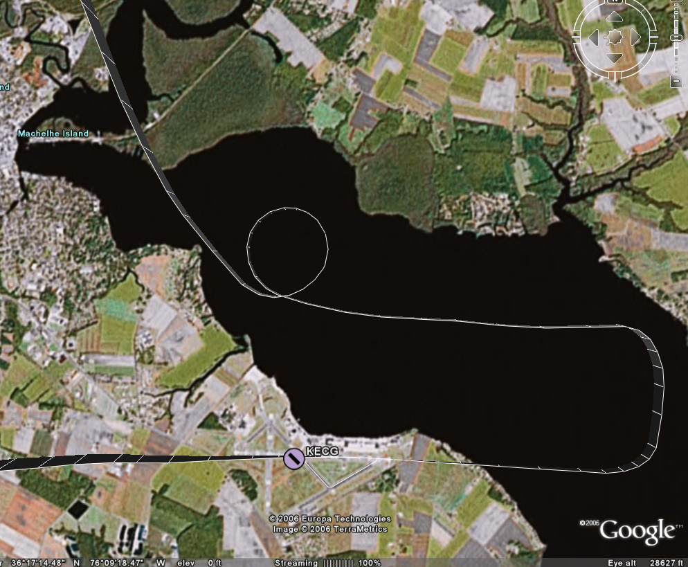
As we got close to ECG (which, by the way, is Elizabeth City Coast Guard station), we were handed off to the tower. A very good-natured guy answered, and I was happy to be interacting with such a positive personality for my first time into a towered field! He told us to set up for right traffic for 28 and to report midfield on downwind. I still had some altitude to lose, so Chuck suggested I tell him we wanted to do a 360 to bleed some off. He approved and said to report when reestablished in the pattern. You can see from the image of the track that we did that over the water, which was neat and a little disconcerting at the same time!

Anyway, we got back into the pattern and -- this was neat -- he said he'd tell me when to turn base. Well, ok then. I'd have to be a little more off-the-cuff with setting up to land, since the normal cues for putting out flaps or slowing down would be out of my control. It ended up being quite odd, though, because we had a very long downwind (extended well past the approach end of 28) before he told us to turn in. It was for the sake of ground operations: a jet and a 4-prop C130 were taxiing across the field. I reported to him when we were on final, and he cleared us to land. (Note: The GPS points say it was actually only a 2.5-mile final, but it seemed a lot longer than that! Final at JGG was less than 1 mile, and final at RZZ was a little over a mile.

And about an hour and a half we did! Just kidding, but that final was so long it seemed like we'd never get there. I had to power back up somewhat to keep from losing too much altitude along this stretch (so that 360 wouldn't have been necessary, had we known this was coming). But we made it to the runway and had a decent touchdown.

Mr. Nice Controller instructed me to turn off at taxiway Charlie, then hook a right and the FBO would be straight ahead. I replied that we'd like to taxi back and depart, and so he told us to take a left off taxiway Charlie instead and hold short for 28. I cleaned up the plane and took that left and followed a C130 to the hold short line, giving him (and his clouds of exhaust) puh-lenty of room. They took off and a short bit later we were cleared to depart straight out, which we did without event.

We compared landmarks to the sectional to decide when we were clear of his airspace and then I radioed to tell him that and thanks. He approved a frequency change and that was the end of that. I dialed in CVI, dialed in the 290 radial and then jockeyed around a little to get on it. The trip to it was uneventful as the flying goes, save for a little waddling around as I lost and then realigned the heading. Mentally, though, it was a little flustering. Chuck was asking me math questions, and I didn't think I was overloaded but I was having a hard time reasoning through. Eventually I started jotting things down on the kneeboard and was able to be more logical about it. It was stuff like "How long will it take us to get to RZZ?" That shouldn't be that hard -- I knew roughly where we were, could estimate from the highlighted path on the sectional how far we had to go, but for some reason when it came to figuring out how many minutes for that distance at our current ground speed (which the GPS gave me in knots), I just couldn't do it! I felt like a freakin moron and that was frustrating.

So I jotted down my little conversion factor -- ( 60 minutes/1 hour ) * ( 1 hour/98 nm ) * ( 42 nm left to go ) ---- so (60*42)/98. Riiiiight. I'm gonna do that in my head at the snap of the fingers. I was starting to multiply when Chuck changed it up and asked how many minutes it took to go one (nautical) mile.

If you have a dog, you know the dog reaction to something they just don't understand. Ears up, eyebrows up, head tilted to the side. That's how I felt.

Ok, minutes per mile. Back to the kneeboard. ( 60 minutes/1 hour ) * ( 1 hour/98 nm ) ---- so 60/98. So I previously had been figuring out just that conversion factor.... Ok, 60/98 is easily estimated to be around .67... So .67 minutes per mile, 42 miles left, 2/3 of 42 would be 28? Ok, 28 minutes to go.

Ugh. That was harder than it should have been. Looking at it, I think I would have been better off to think of 42/98 -- a little less than half -- and then take that portion of an hour.

So, whatever. I'll come back to this later.

A few minutes later another math problem: How far from the airport should we start our descent? Hmmm, oh, ok. We're at 4500', pattern altitude at the airport is ~1000'. So we've got 3500' to lose. Let's assume a nice gentle 500'/min descent. So we need 7 minutes. That one was easy enough.

Now what? What distance from the airport corresponds to 7 minutes? ( 98 nm / 1 hour ) * ( 1 hour / 60 minutes ) * 7 minutes ---- 98 * 7 / 60. I didn't get it in the air without some more leading questions from Chuck to break it down, but now when I look at it it seems easy -- 98/60 is roughly 1.5, time (round up to) 10 is 15. 15 miles out, plus a few miles to be near pattern altitude to check out the field and get settled in the environment. So at 18 miles out we'd start the descent.

Ok, fine. Except it didn't totally go like that. There was some other intermediate conversion factor in there, and I don't remember it specifically, but there was one on our final leg, so I'll think about it more in a few minutes...

The other thing that happened to fluster me a little was that during our discussion about how turbulent it was that day -- it was coming in waves where we'd have several minutes of nice calm air then several minutes of big bumps -- Chuck asked what we can do in the yellow arc on the airspeed indicator. The phrasing of the question threw me off. The yellow arc (on ours) goes from Vsse to Vne. I knew Vsse to be the "don't go faster than this in turbulent conditions" speed. But what can you do in that speed range? I don't know. The answer basically is that you can fly straight-and-level in the yellow arc. You don't want to stress the plane at those speeds, so you don't fly in that range when it's turbulent. You don't do maneuvers at those speeds.

When we started the descent, I was glad to be done with trying to maintain that radial from CVI to RZZ (again, you can see the squirreliness in the track). The sectional indicated that the airport was southwest of "stacks" on the edge of a town near the lake. I found the lake, found a town, and saw a plant of some sort that did have some vapor exhaust, so I started pointing to it, which was a little to the right of the nose. As we got closer, however, I realized that there was another town with two much taller stacks a little farther from the water. Consulting the sectional again showed that these taller stacks were the ones that led to the airport. I pointed back to the left a touch, and before long a nice clearing appeared with a long edge oriented the way we expected the runway to be. Sweet.

I called UNICOM, and a pleasant woman answered that we'd be using 23 and asked if she could get us a car or fuel or anything. Wasn't that nice? We wouldn't be needing anything, and so I swung wide to the southwest to get on a 45 for left downwind for 23. We had a decent, almost-perpendicular-to-the-runway crosswind at this point in the flight, and could see that the windsock down there was almost fully extended.

I started my usual pattern -- at 1000' for this airport -- abeam the numbers, and started to descend. I had overlooked that one little detail that this field's elevation is 200' higher than home, and for roughly equivalent pattern altitudes something would obviously need to change. Well, obvious to Chuck and obvious to me after he pointed it out. I powered up to stop the descent, and had also been planning on a higher airspeed over the threshold, so this was ok. As I turned final, directly into the blazing lowering sun, I was at ~500' over the field, had two notches of flaps out, and was doing the constant-correction technique. I crabbed a little, and then I decided to slip a little, and kept aligned with the right edge of the runway (the wind was from the right). I had another decent touchdown, but as I started to brake and the nose came down, the nosewheel started shimmying like it wanted to come off!

I pulled back on the yoke as far as I could with one hand, trying to get the weight shifted back to the main wheels and the shimmying to stop. Chuck hopped on to help me pull back farther, and it did stop. As we slowed and the nose rotated down, it started again. This time I jumped on it with both hands and got it under control myself. (On Wednesday (after this x-c which was on Tuesday), Husband met with the mechanic for a few different issues, and they pulled the nosewheel shimmy dampener and found that the seals had dried out and there was no hydraulic fluid left. Mechanic was supposed to fix it that day, I think.)

We taxiied back to the approach end of 23 (which I incorrectly and generically called the end of 5) and took off into that inconveniently located sun. We departed and rose to ~1200' before turning off to the left and following the pattern as we continued to climb. As we left the airport I checked my nav log for the DR "settings" for the first checkpoint and set us up. We headed out and continued climbing to 3500'.

I really fought to keep on the heading for this exercise, knowing that being off by a degree would have a bigger impact the farther I went. Granted, each checkpoint was only 16-18 miles apart, but still... Much to my astonishment, we were dead on for EMV as far as heading goes, and were only about 20 seconds late in getting there. (Since RTFP doesn't build in time for the climb out of RZZ, that seemed pretty good o me.) Enthused, I reconfigured us for the next checkpoint.

This time, I was bad. We were on course and I was holding the heading pretty well. I even had it trimmed well enough that when Chuck said to let the plane fly itself (no autopilot, remember), it held 3500 nicely and except for the occasional bobble from the wind it stayed true. What was bad, though, is that as the time for AKQ was drawing near, I started cheating. AKQ is hard to find, and if we weren't dead on I wanted to be prepared for whatever correction would be needed. The only thing that helps to find it from 10 miles out is that it's just north of a little town in the middle of woods and farmland. I saw a town, and I even thought I could make out the white radar dome. So I nudged our nose just slightly to the left to point us toward the town. That was bad, and I learned my lesson. My eyes fooled me, and that wasn't the right town. As we got even closer, I couldn't find a runway, so I glanced down at the GPS -- we were several miles west of the airport! In looking at the GPS track above, you can see where I nudged left going up to AKQ, and how if I had just stayed the course we would have been really close.

From there I could see the curves in the river that cradle JGG so we just went by pilotage the rest of the way. Somewhere along this last jaunt we talked about how next time we'll use the E6B wind wheel to make adjustments on the fly (ha ha ha, that pun never gets old), and then came the last piece of math.

The part of this math that stands out in my mind was that 102 - 60 is 42 and 42/6 is 7 so we have 1.7 of something... minutes or miles and where did that 6 come from? 102 was our groundspeed at the time, so that would be 1.7 miles per minute. I've tried that with a few other numbers and it's a math trick -- find an even number of times it'll divide (in our case 1, but think about something like 330/50, where it would be 6). Take the remainder (42 or 30) and divide by the original divisor divided by 10 (6 or 5), then put it together with a decimal and you'll get your answer (1.7 or 6.6). Ah, yes, introducing the decimal justifies dividing by 10. This obviously works nicely for divisors that are multiples of 10. Now why were we figuring that out? Oh, well, if we were deciding when to descend, we'd know how long it would require to get down, so this factor would tell us how far from the airport we'd need to be when we started the descent.

The landing at JGG was normal with the exception of another nosewheel shimmy. I was nowhere near as tired as I expected to be.

(Don't make fun of my gum-chewing! It helps me to fly better, I swear! And you can see just how bad the sun was at RZZ.)

Discussion:
  1. ATC, approach, etc: I haven't really figured out the flow for these interactions yet. What helped me to get a grip of the various emergency procedures was to understand the flow -- for instance, in flight engine loss goes preserve altitude, figure out where to go, try to restart, communicate, shutdown. That's a logical sequence of events, and each of those items has a set of tasks associated with it.

    I figure there'll be some nice flow for talking to ATC. Something like hail them, give location and intention, respond as appropriate. But when talking to approach maybe it's different, more like hail them, give intention, respond as required. Getting an understanding of that will make it easier to fill in the details. And with experience hopefully it won't seem like a random and blubbery chat every time....

  2. Dead reckoning: So this is the kind of navigation that I've talked about with Husband and said repeatedly that I just don't see how it could work. It seems like there are so many factors, and so many things that could change between when you do your calculations and two hours later when you get in the air and two hours after that when you get to the later checkpoints. But I'll be damned if RZZ to EMV wasn't perfect empirical evidence that it does in fact work. And I'll also be damned if EMV to AKQ wasn't perfect empirical evidence of screwing up what would have worked by thinking I knew better than the calculations. I mean, you've gotta be heads-up and flexible and ready to adjust your plan, right? But I misjudged and proved that changing the plan without a good solid indisputable reason produced the wrong results.

  3. Math: I'm an engineer. I don't hate math. I assume that (1) just like the whole can't-do-math thing from one of the first lessons, after I'm used to the various things that are going on during a cross-country it'll come easier and (2) after I've done those kinds of calculations a few more times and am familiar with what I'm trying to determine and how best to get it it'll come easier.

    The workload thing (#1) is a cop-out explanation, though, since it wasn't like I had to do math while listening to a controller or something; the math came at times when it was just normal flight.

  4. Husband: Husband said he was proud of me and my progress and he'll have no problem whatsoever letting me do everything on the next trip. The previous trips I've done everything in-flight, but no takeoffs or landings. Plus, next Monday he's going to do his BFR with Chuck, and do it from the right seat.

  5. Tracking a heading: My goodness. When we were in the air, I knew I was doing a little meandering and realigning on the heading, but I didn't think it was nearly as bad as what the GPS track shows! Is that amount of divergence normal, or a sign of inexperience, or a sign of too little focus on heading, or what? On the one hand, I'm being pretty hard on myself about being sloppy, but on the other hand, I'd have had to spend twice as much time looking at the heading indicator and cross-checking the mag compass for accuracy to have stuck it better. I'm guessing there's a reasonable balance there. I also wonder whether a less turbulent day would have made a difference -- there was a sigmet for moderate turbulence, and the ECG-RZZ leg did have a fair amount of bumps, but does turbulence affect the heading-tracking ability much?


Self-Assessment: More polish, more practice, especially on the com!
    Flying
  • Preflight, taxiing, normal takeoff, short-field takeoff: Good.
  • Soft-field takeoff: Needs practice.
  • Maintaining airspeed, stalls, slow flight (VR/IR), maintain/change attitude/altitude/heading by instruments: Good.
  • Recover attitude, altitude, heading by instruments: Acceptable.
  • Forced landing: Good, need more practice.
  • Forward slip:: Dunno, needs more practice.
  • Pattern, normal landing, directional control after landing: Good.
  • Crosswind landing: Decent.
  • Radio work: Untowered, good; everything else, needs focused practice!
  • Short-field landing: Improved.
  • Soft-field landing: Not sure...
    Navigating
  • ADF: Okay for an intro, needs practice.
  • VOR: Use of is good; tracking the heading needs refinement.
  • Dead reckoning: Gotta trust the numbers! Also we'll practice adjusting the numbers in-flight for differing circumstances next time.

Next: I've got the plane Monday afternoon for another x-c, assuming Chuck is up for it after Husband's BFR.
  • More cross-country planning (with just-prior wind calcs!).
  • Short cross-country trip.
Hours logged this flight: 3.0
Hours logged total: 29.8
Instrument hours logged this lesson: 0.0
Instrument Hours logged total: 1.6
Take-offs and landings this flight: 3
Take-offs and landings total: 80
PIC hours total:: 5.7

Monday, December 04, 2006

X-c tomorrow?

Perhaps...

The winds are trying to die off, but in some spots right now they're still forecasting gustiness.

I've got the route worked out.

Leg 1: JGG -> ECG by pilotage, 3500'
The route should be ~66 nm and should take ~40 minutes and a conservative allotment of 6 gallons of fuel.

The leg will start by heading south of JGG to the Surry area to dogleg around the FAF Class D airspace. (Although since part of this trip is to start talking to towers, maybe we'll contact them and then fly straight through....) Then we'll go down the southern shore until we get over the Aberdeen private strip (nicely paved and maintained, by the looks of it -- it's easy to pick out). Then we'll turn to a heading of ~167 (adjusted for whatever the wind conditions actually are tomorrow) and just stick to that heading until the Elizabeth City airport. Along the way we'll pass by PVG (where 388 had work done on the VOR indicator), a spot where we'll be over a big highway with a good-sized lake to the right and Chesapeake airport to our left, and a nice big inlet that leads out into the Outer Banks area, and ECG is at the outlet of the inlet.


Leg 2: ECG -> RZZ by VOR nav, 4500'
ECG has a VOR. CVI VOR is midway between ECG and RZZ. Should be a pretty straight-forward leg.

CVI is on ECG's 290 at 35 nm; RZZ is on CVI's 285 at 41 nm; I'm going on the assumption that the signals will be receivable along the whole route. The whole leg should last 47 minutes and take 7 gallons of fuel.


Leg 3: RZZ -> JGG by dead reckoning, 3500'
The path here is:
Heading of 46 degrees (adjusted for tomorrow's winds) for 12.5 minutes. That should put us over KEMV.
Heading of 61 for 10.5 minutes. That should put us over a little lake.
Heading of 62 for 7 minutes. That should put us over KAKQ; this will be a good test: on the best of days and even with GPS assistance, Wakefield can be very, very hard to find!
Heading of 63 for 16.5 minutes. JGG ought to be right there. (RTFP thinks this heading should be 52, so I'll have to double-check my measurements. That part of the sectional has been folded and refolded about 19 billion times, so it could very well be my error.... which just underscores the fragility of this method and emphasized how good it is to get new sectionals frequently!)

All told it should be just over 2 hours of flying time.

I may try to pick up flight following, but since each leg is only ~40 minutes, I'm thinking it isn't worth the extra overhead on this trip.

Using the analog E6B tonight was easier than last night, but it's still a pain in the rump.

Sunday, December 03, 2006

X-c delayed

Tomorrow they're calling for high winds and some areas along the x-c route will be gusty. So we're pushing the trip back to Tuesday afternoon.

Tonight I did the route (which may change; waiting on info from Chuck) on a nav log worksheet I found here. The route was JGG -> RIC -> RZZ -> ECG -> JGG.

After much swearing and irritation, I got everything done with the "analog" E6B. Part of it really, really didn't make sense -- like when trying to determine how long it takes to climb to 3500' from sea level at a climb rate of 840'/min. My brain quickly estimates that to be in the neighborhood of 3.5-4 minutes. The E6B, when read according to its instructions, tells me 2.1 mins. (If, however, I look at the hours scale instead of the minutes scale, it shows ~3:35, which jives with the mental math.)

In any case, I brute-forced my way through it (no wind corrections) and found that it would take 2:30 for 239 nm and we'd use ~18.5 of the 38 gallons of fuel. I calculated the time and distance for the climb-out portion of each leg, and used the remaining leg distance for calculations at best cruise performance. I did not deduct anything for lower fuel consumption on descent, figuring that could be some built-in buffer. I also used different burn rates for different altitudes, as specified by the POH.

AOPA RTFP came up with similar but different numbers. It says 2:22 for 239 nm with 17 gallons of fuel.

I learned two main things from the comparison between the by-hand method and using the RTFP. First, RTFP rounds fuel consumption up to the nearest whole number. I had been rounding up to the nearest half-gallon, but building in even more buffer seems like a reasonable thing to do (especially since I don't really know whether the POH's estimates still hold, 40 years later!). Second, RTFP isn't as flexible and therefore may not be as accurate. For the four legs in my route, I was planning to fly three different altitudes. RTFP only allows you to specify one altitude to use for the whole flight, as far as I can tell. My POH says the burn rate is worse the higher you get, so that could have an impact on the whole trip. Those two factors would reasonably explain the difference in the time and fuel estimates.

Oh, I guess I learned a third thing: RTFP beats the pants off a manual E6B in the user-friendly and time-efficient categories!

Saturday, December 02, 2006

Practice x-c

[Update: Link at bottom.]

Husband and I flew over to Luray (W45, Luray, VA, of Luray Caverns fame). We had a jerk of a headwind going out there, so what would be 1:10 in calm conditions was 1:45. Coming back, though, we made excellent time -- 1:01.

Husband did all the flying on this trip. I followed along on the sectional on the never-ending trip out there, practicing identifying features on the ground and correlating that to landmarks on the sectional. Pilotage practice, we shall say, and a few instances of using intersecting radials from different VORs to pinpoint a location on the map.

On the way back, I also did the radio calls. This was first to get flight following from Washington Center, who handed us off almost immediately to Potomac Approach. There were a few traffic advisories, but nothing major.

Flying to and over the mountains was neat and pretty; from the picture above, you can see why they call them the "Blue Ridge" mountains. The clouds on the way back were fantastic. The sky looked furry.

I'll try to write up more tomorrow; it was good practice for navigate and communicate.

Update: Husband wrote up an account on his blog Vectors To Final, and put up some other pics and some video.

Friday, December 01, 2006

Possible x-c routes

My ability to focus on work is totally hosed now. That big outstanding "what will we do on Monday?" question is much more interesting than writing a heat map visualization tool for mass spectra-based disease classification results.

So I'm thinking two possibilities right now, either one of which will require approval from Chuck. Whenever Google Earth finally finishes downloading, I'll take a look at the route that way and also I've gotta check the sectional(s) when I get home.

Possibility the first:
KJGG -> RIC (33 nm, Class C) -> KLYH (90 nm, Class D) -> KLVL (75 nm, untowered) -> KJGG (59 nm)

    Pros:
  1. Class C & Class D airspaces, both on the early side of the trip when I'll be fresher.
  2. Lynchburg field elevation is 938', which is higher than anything around here, so that'll be different.
  3. The eastern third of the trip will look familiar.

    Cons:
  1. Still kinda long (2:28 flight time)
  2. Flies over Farmville MOA (ceiling 5000'), so I'll have to determine how we'd leave KLYH in order to avoid it (above or around?), and overflies Pickett Two (restricted up to 10000'), so I'll have to determine how we'd get around to KLVL.
  3. The sectional will say for sure, but there don't appear (from AOPA RTFP) to be many natural landmarks for pilotage on this route.

    Other:
  1. 257 miles, 2:28


Possibility the second:
KJGG -> KECG (64 nm, Class D) -> KRZZ (75 nm, by way of CVI VOR) -> KJGG (68 nm)

    Pros:
  1. Class D airspace, first waypoint.
  2. Much of the trip would be familiar territory.
  3. The legs are not too long, though in all honesty the numbers show them as similar to the other route (except for that 90-nm leg).
  4. KECG->KRZZ has good natural landmarks.

    Cons:
  1. Too simple?
  2. Too short?

    Other:
  1. 207 miles, 2 hours


Neither of these trips (with no wind) would require refueling; the first would use 22 of 28 gallons, the second 18. Both routes have airports with fuel available. Both give exercise with VORs, different airports, at least one towered airport, opportunities for pilotage (duh, right?), ...

Or maybe it'll be something completely different...

Cross-country revision

As I thought more about the planned route for this first cross-country, I became more and more anxious about it. There are two problems for me: (1) lots of new stuff and (2) a long flight that, because of the new stuff, may be a stressful filght.

The new stuff is the main thing. Planning a cross-country. Landing at new airports. Going to a towered airport for the first time. Going to unfamiliar countryside. Going near an active MOA. Major navigation. Cockpit management for multiple sectionals and airport diagrams. Potentially updating the ETAs/fuel estimates based on in-flight experiences. Et cetera. A lot of that really is just stepping up the level of things I'm already doing -- landing somewhere else should be pretty much the same, using a different VOR is the same as using HPW or HCM, avoiding an MOA is the same as avoiding FAF, etc. But the fact remains that it's 3 days from now and my stomach is in knots thinking about it!

As for the length of it, three hours doesn't seem that bad on the surface; when Husband and I flew to KUZA six or so weeks ago, it was over three hours and I flew almost the whole way. However, that trip was a direct route for a leisure trip and he did the takeoff and landing. For this trip, it's supposed to be more taxing to develop skills beyond just maintaining heading and altitude for 300 miles. Taxing plus long makes me a little uncomfortable for a learning experience; for a long solo cross-country it'll be fine, but I just wouldn't see it being an effective learning experience if it's overwhelming.

So I emailed Chuck about it and let him know how I'm feeling. I suggested that I could draw up a route that I'd be comfortable with that would include a towered airport and any other criteria we needed to hit. He approved of this plan, so my task is to design a route that hits a towered airport and has 3 legs of at least 50 nm.


Now for the really touchy-feely part. Last night as I lay awake at 3 am thinking about the cross-country, I decided that the plan wasn't the right one. I wasn't looking forward to it; in fact, I was dreading it.

But you know what? I'm capable and confident enough now to know that I can change my training. The problem isn't me, or Chuck, or the process, or flying in general. The challenge is just the pace (which I guess is a combination of all of the things that were just acquitted!). The syllabus can't be a one-size-fits-all syllabus. This time, I heeded my apprehension and changed the pace.

On the other side of that coin, however, is that persistent self-doubt. What if I'm just wussing out? I mean, I'm not eliminating the challenge, but what if it's being attenuated too much? Am I doing myself a disservice by not trying to overcome it? If I'm not pushing hard enough, will I be getting enough out of it?

I've made the decision, and I believe it to be the right decision, but there's still a little pompous character in my mind shaking her head in disappointment and tisking at me, saying that I could handle the original plan and that I'm taking the easy way out. She's wearing really ugly red-rimmed glasses. Ah, I digress.