Showing posts with label cross-country. Show all posts

Saturday, April 21, 2007

Birthday Jaunt

We just got back from Husband's birthday day trip (his birthday is later in the week, but today was irresistible) up to KGED (Georgetown, DE). It was a really nice trip! He did 3 hours of sight-seeing, and I got 3 hours of flight time.

We left JGG by 31 around 10 am, turned west for the noise abatement. I called Leesburg Radio and opened our VFR flight plan, then headed northeast for Mobjack Bay and the narrowest passage across the lower Chesapeake Bay. We got to our target bay-crossing altitude of 7500' a few minutes before running out of land, and up there it was a little chilly even though on the ground it was already in the upper 60s. The air was nice and smooth, and the bay was already thoroughly dotted with boats.

It was a gorgeous, nearly cloudless day with good but not "severe clear" visibility. Once we crossed the bay, I took us down to our cruise altitude of 5500' and pointed us NNE. We'd be overflying Accomack County (MFV, I think), traffic for which is frequently heard all the way down at JGG. We flew along the eastern seashore, Chincoteague and Assateague. We flew just west of Wallops Island, a military field (maybe AF?), and could see the buildings of Ocean City, MD, off at the very edge of the Atlantic Ocean.

It was a super trip, the kind of really good and easy trip that perfectly exemplifies why I learned to fly. Husband is putting up some video he took en route and also of my landing at GED (below). When we landed and were directed to transient parking, three ground crew members came out to help us push back and with chocks, and within moments the fuel truck was there to top us off; great service here.


Landing here for me was pretty neat. It's the first time since finishing training that I've gone to an unfamiliar airport, or gone on an unfamiliar cross-country flight (as PIC). I did the usual preflight prep, checking weather, using RTFP for course plotting and filing the flight plan, checking for TFRs, etc. I had picked out several airports along the way and printed out their kneeboard pages from the AOPA database, including GED's, of course. But actually going to that airport with so little research was neat. The only other time I've really gone to "new" airports was during training, and as a student I was anal (who, me?!?!?!!!) about knowing every available detail about the airport and surrounding area so there would be no surprises. I knew I had everything I needed for the destination, we'd have two GPSs and the sectional, so we were good to go without having to spend two hours planning and analyzing the trip! Approaching the airport, Husband helped me plan our descent from 5500' to pattern altitude of 1050', I executed that and got into the traffic flow with ease. Training apparently worked as it was supposed to have worked, because there were none of the comfortable visual cues of homebase, just the runway to use as a guide for the pattern and everything went just right.

Sussex County Airport (GED) has a nice little restaurant called the Flight Deck. They've got a good-looking menu, and we were both delightfully satisfied with our meals; a ($100) cheeseburger and onion rings for Husband, and broiled flounder with coleslaw and sweet potato casserole for me.

After a nice lunch, we paid for our fuel and headed out to the Delaware Aviation Museum, which is right there on the grounds. Out in the grass between the taxiway and the runway they have a collection of deteriorating Migs. I thought the noses had a neat design.

We then went through the museum, guided by a nice lady name Charlie. It's not a big place, but there are lots of neat artifacts. Apparently, all of the stuff there was collected by Larry, a B-24 (or 25?) pilot who lives in the area. Here are two of the exhibits in there. On the right, those are recon cameras; thank goodness for the tiny digital technologies we have nowadays!

Just before finishing up with the tour, the medevac helicopter pilot who was on waiting duty came in and said a Corsair was in the pattern. We went out to see it land, and it was followed by a P-40. Those things are huge! The wing design of the Corsair is really neat, too.

Departing the airport was easy. We had come in on 22 and departed 4. We turned out to the west, dodged some restricted airspace, stayed well east and south of the DC ADIZ, and picked our way back home. The air was a lot choppier as we came home, and I abandoned our 4500' first choice for cruise and went up to 6500' where it was generally much smoother. I had some of that weird unsettling feeling in the turbulence, which was nothing as far as turbulence goes, but stuck it out (I just annoyed husband with some of the whining...); luckily most of the return trip was smooth! Just some thermals as we move into warm weather...

We landed back at JGG, safe and sound, on 31 around 4 pm. We swapped places so Husband could get a trip around the pattern in before we shut down for the day.

What a nice day! :)


I'm up to 67.1 total hours now. And both takeoffs and both landings were one-handed.

Sunday, February 25, 2007

Checkride Part 2a: The flight exam

So you know from reading the the beginning of the oral exam post that it was uncertain due to winds whether the checkride would actually transpire today. The little voice in my head was thinking about the wind conditions for my first solo, and I gotta admit that made the hairs on the back of my neck stand up. But I've come a long way, baby, and am much better equipped to handle some bumps now.... Still, these could be major bumps, and the questions of (1) aircraft crosswind limitations and (2) personal limits had to be asked.

When I departed for AKQ, the winds had settled somewhat and were within both plane and personal limits. On the high end of the limits, but within. Pre-checkride forward-slip landing practice was canceled on account of the winds, but closer to the zero hour it was acceptable.

This is what the conditions were between the time when I arrived at AKQ just before 11 am and just after I left a little after 4 pm:
KAKQ 241954Z AUTO 03011G16KT 10SM CLR 09/M12 A3018 RMK AO2 SLP222 T00941117 TSNO
KAKQ 241854Z AUTO 03005KT 10SM CLR 09/M12 A3019 RMK AO2 SLP226 T00891122 TSNO
KAKQ 241754Z AUTO 01007KT 10SM CLR 08/M12 A3021 RMK AO2 SLP233 T00781122 10078 21061 58018 TSNO
KAKQ 241654Z AUTO VRB06KT 10SM CLR 06/M14 A3024 RMK AO2 SLP243 T00561139 TSNO
KAKQ 241554Z AUTO 36010G16KT 10SM CLR 04/M14 A3026 RMK AO2 SLP250 T00441144 TSNO
KAKQ 241454Z AUTO 33008KT 290V010 10SM CLR 03/M16 A3026 RMK AO2 SLP251 T00281156 50009 TSNO

Big fun, eh?

So after the oral exam, we headed out to 388 and Linda asked me to do a thorough preflight, except that fuel samples wouldn't be necessary. I was to talk her through the process and point out where samples would be taken. I was actually caught a little off-guard by that. I figured that since the plane had been out of my sight for over 2 hours at an unfamiliar airport that sampling I would need to do. It may have been a challenge from her to see if I, as PIC, would do the conservative thing or not. I did not check the fuel, and she didn't say anything about that.

I walked around with my checklist, and about the time I got past the right wing up to the nose she got chatty. Ah, perhaps this is a distraction test. She asked me a question, and I heard her but blocked her out long enough to mark my place on the checklist. I then talked to her and came back to my checklist, letting her know I was going back two items in the list to ensure that I hadn't missed something. Score! A minute later the same thing happened again, and I responded the same way. Then another pilot based at AKQ came out and talked to her so I was largely unsupervised for the rest of the preflight.

We hopped in and got organized. I noticed that she didn't fasten her seatbelt, and assumed that was another test -- she has to have billions of hours, so not buckling up wouldn't be a mistake on her part. I didn't say anything yet, knowing that it was one of the first few items on the in-cockpit checklist. Preflight inspection, complete. Passenger briefing -- here we go. I explained how the seatbelts work and asked her to fasten in and tighten down, then explained the door operation, then asked her to not touch anything unless we had an understanding about it, and asked her to continue the briefing so we would know what to expect on the flight. She said we'd start with the x-c and at some point would break off to do instrument work, maneuvers, and so forth then do some landings and debrief at AKQ. Super! I was so excited!

The rest of the preflight was fine and normal and before long we were rolling to the threshold. At AKQ you enter the runway pavement on the numbers for 2, so if you want 20 you have to back-taxi the entire length. I paused before the threshold line to assess the current winds. Variable, still, but favoring 2. Well at least that part would be easy! I announced that I was departing 2 and would leave the pattern to the northeast.

And that I did, though the mechanical turbulence over the treetops, and began my climb to the x-c cruise altitude of 4500'. It was bumpy all the way up, as expected! The surprise was that at about 4400' the chop switched off, just like that. The whole x-c portion at 4500' was actually nice and smooth! I got an opportunity during the climb, though, to demonstrate traffic-scanning effectiveness; maybe ~2500' I saw a twin-engine out in front of us going the opposite direction, perhaps half a mile or so to our left and a couple thousand feet above. I pointed him out as "no factor" and continued the climb.

Here's an overview pic of the checkride flight (click to enlarge):


What I've learned from x-c planning is to not start the timer between checkpoints from takeoff, but rather from the first checkpoint, selected to coincide with reaching cruise altitude. I had shown Linda the calculations that did take that climb leg into account for total trip time and fuel consumption, and she ok'd that plan. I hit checkpoint #1 just below 4500', but started my timer anyway and jotted down the time and the ETA for checkpoint #2. I then checked the sectional to be positive of our position. Linda was pointing out features here and there and amidst scans for traffic and scans of the instruments I would indicate whether they were or were not on the sectional. (In the debrief she praised my pilotage skills! :) ) Of course, those could have been distraction attempts, too, because she had quite a few things to point out.

The second checkpoint would be a turn in the power lines we were following. We got there just barely behind schedule, which surprised the hell out of me since the winds now were supposed to be dramatically lighter than the ones predicted when I had done the calculations earlier in the morning. Something was wrong, but I didn't put my finger on it yet... I knew the plan was to fly straight (as though the power lines hadn't turned) until we hit I-95, then turn SSW. We got to I-95 ahead of schedule, according to my navlog calculations. Hmmmm...

I turned off SSW and followed the interstate with it out my window, since that was the plan. I consulted the sectional to make sure that the interchange on I-95 that was the checkpoint was indeed the one I expected. It was. So what was wrong? Why were the times off, and off inconsistently?

Duh! I wanted to throw myself out the window in shame! For the whole trip, I had picked 17 checkpoints, and that required two navlog forms. I had the second page of checkpoints on top and hadn't noticed! Bonehead! I made this realization and was analyzing my options (transfer times to the right log boxes? ignore those first two and just get back on track by starting the timer at the next checkpoint?) when Linda asked me to calculate our groundspeed based on the past checkpoints and then estimate remaining time en route. I immediately admitted my mistake and said that I planned to start the timer at the next checkpoint to get on track, and that after the following checkpoint I could do that calculation.

Still suffering my self-humiliation, after hitting the checkpoint and starting the clock I realized that I didn't need to do that to give her the time en route. The last minute of shame fell away completely as I refocused and pointed out that the GPS gave me groundspeed and suggested that I could calculate from that. She approved, I did the math, and came up with roughly an hour to get to LHZ. She was satisfied with that, and I felt a little better.

After one more checkpoint, Linda had me go under the foggles under the guise that we had just unexpectedly flown into clouds. I said I'd be doing a left 180 to go back to VFR weather, but first I wanted to tip my left wing so she could check for traffic for us (brownie points!). I did a nice standard-rate 180, maintaining altitude pretty closely.

Then she asked me to descend to 3000' while maintaining heading. I felt I did that right-on, but the GPS shows some slight right deviation. My first thought is precession of the heading indicator, but it wouldn't precess that quickly, I wouldn't think, and I don't remember which way it precesses anyway.

Anyhow, at altitude she had me turn to headings by IR. These were, in effect, clearing turns. Foggles off, time for stalls!

I swear we did a full-flaps approach-to-landing stall first, but the GPS track indicates a power-on stall first. In any case, I was glad that Chuck had run stall drills in one of our recent pre-checkride flights! The power-on stall was good, and the full-flaps stall, done while turning, seemed good to me. In training we rarely did full-flap stalls, if ever (I'll have to review my flight (b)logs!). The only thing I could remember was what I knew I had been taught about a go-around from a full-flaps configuration: half power, flaps to 20, full power, Vy, milk the flaps the rest of the way. Not using full power initially is to avoid a sudden nose-up; made sense to me that you'd use the same procedure to avoid a secondary stall. So that's what I did, and didn't lose much altitude at all. She didn't say anything then, but when we got back for the debriefing, she laid down the law: always go full-power when recovering from a stall, period. Period.

Staying in slow flight, I let the stall warning squeal while doing requested clearing turns. The foggles then came back on for unusual attitudes. The most inexplicable part of the GPS track is, naturally, during this portion! See that abrupt left (you can't tell from this view, but the side-view shows a roller coaster for altitude, too!) followed by some straight flying (the recovery portion, regaining desired heading and altitude), then a tight-tight climbing turn? Yeah....


After the unusual attitudes, which went just fine, Linda asked for a steep turn. I said that I'd do clearing turns and then start a left-hand steep turn. Near the end of the first half of the clearing turn, she suggested that I go right into the steep turn, and I agreed after vocalizing that I thought it would be ok to use that as the completion of the clearing turn. My left steep turn wasn't very pretty -- a little tight and not ended in quite the right place -- but the altitude was good and that's the #1 thing I was being anal about! As I got perhaps 3/4 of the way through it, she instructed me to go straight into a right-hand steep turn, which I did. Again, not beautiful, but better than the first and the altitude was right on.

I stabilized coming out of the steep turns and had my hand on the throttle, finishing the throttle/altitude/airspeed balancing act, when suddenly she put her hand on top of mine! If I hadn't been surprised I would have been suspicious -- odd time to put the moves on! :) Ha ha ha... I hesitated for a second, glanced over at her, and when she didn't move her hand I decided to withdraw mine. You probably guessed it: simulated engine failure. She pulled out the throttle and sat back to watch.

Instinct is a good thing, and practice gives you that! I talked through what I was doing: trim for best glide speed of 80 mph, pick a landing site and fly towards it.... As you can see from the pictures, southside Virginia is thoroughly bespeckled with fields, so finding a landing site should have been easy, considering we were at something like 3000' when I "lost my engine." But I had a dickens of a time picking a field! First, thinking out loud all the while, I was attempting to assess the winds to see if a particular field orientation would be better and to determine my landing direction. The surface winds had been generally NNW (but variable) when we left the airport, and we were within 15 miles of Wakefield, by my estimation. But I wasn't positive that that was correct now, especially given the variability. Franklin was basically directly in front of us, and the smoke stacks there seemed to indicate a wind from the southeast.

Ok, I'd go by that. I wanted to land on an southeasterly heading, so I started eliminating fields: this one's too short in that direction, that one's good-sized and aligned right but those power lines, ... I swear, it seemed like we had all the time in the world, so I let the standards be too high and just kept looking, confident that I'd spot the right one for the exercise, and frequently checking out the right side as well.

My training says to cross mid-field at 1100' AGL, hit the key point between 800' & 900', and do what you gotta do to get down from there. About the time we were at 1500', I checked the smokestacks again -- the smoke was blowing *to the southeast* now! Yay, variable winds! It was also about that time that I realized the field I was going for had goats in it. Drat, scramble time! Luckily, I looked out Linda's window and there was a gorgeous big green perfect field to shoot for, so I immediately turned right to fly over it, and was over at just under 1100', then did a good normal pattern with 20 degrees of flaps, and as soon as we cleared the trees she told me to abort.

Whew! You can certainly see the lesson in that, in what I did wrong, and we talked about it at the debrief.

As I was cleaning up and climbing, she pointed out my window at a trio of old abandoned-looking barns in the middle of a patch of fields. She asked me to do a turn around a point around those. I said I'd go up to 1000' and do it from there. Another check of the smokestacks indicated winds from the southwest; I explained that I'd use a northeast heading as my downwind entry into the maneuver and did that big loop-de-loo to get positioned right. It became obvious that the winds were not what I thought, or at least they weren't being consistent. I really don't think she had noticed how non-circular my turn was -- she was dialing in Franklin's ATIS and CTAF (presumably so we could shoot landings there). About 2/3 of the way through, though, I was irritated by my turn performance (altitude was just fine) and told her that I was dissatisfied, that I felt that just at that moment the winds were at our back. She said "Okay, then do another one."

Me and my big mouth, huh? But I did it, and as you can see from the GPS track this one was pretty darn good! :)

You know what, that's quite enough for this post! I'll publish the finale, including the reasons why I thought I wouldn't pass, in a bit!

Tuesday, January 09, 2007

Mixed emotions...

Forgive me for a short post. The x-c went very well, I got in 3.0 hours and 2 landings at controlled airports, so I've now satisfied all of my solo requirements.

Husband's grandfather passed away this morning while I was nearing home base, so we'll likely be heading back south for his funeral in the next day or two. Please keep Husband and his family in your thoughts.

Friday, January 05, 2007

Solo x-c prep

[Update: Dammit, it's looking gusty tomorrow, with base winds near my x-wind limits...]

I'm hoping to finish out the solo x-c requirement tomorrow. I'd like to leave around 10 am, but right now they're saying a cloud deck at 1000' until lunchtime, so it may be delayed a tad.

The plan will be JGG->CHO->JGG for ~2 hours of flying time plus land/taxi/takeoff. I'll have to see how the Hobbs is going on the way home and maybe divert down to AKQ or something if the winds have shortened the trip. Or maybe go past JGG to PHF for the last towered airport landing. Or go JGG->CHO->PTB->JGG.

I just don't know! :) Depends on how the weather shapes up.

Wednesday, January 03, 2007

JEP FII-??: Night Cross-country

Goals:
  • First night flight, with night landings, of course!
  • Night x-c.

Flight:
Tonight I had my first night training flight. After the long holiday, I had a bit of trouble getting in touch with Chuck, and I was feeling a little (self-imposed) rush to get night time in at the beginning of this week since there was a full moon and later in the week new storms were to roll in. When he did get back to me, he suggested I contact Dan (the instructor who did my phase check) since Chuck wouldn't be able to fly at night this week. I did so, and Dan was gracious enough to trade shifts at his part-time job to free up his evening for the lesson. We arranged to meet at the airport at 5:45 and for me to have planned a x-c down to ASJ (Tri-County Airport in Ahoskie, NC).

I got to the airport early and preflighted in the dark. That took about twice as long as usual, and I kept feeling disoriented with my checklist. I think this was because I couldn't just hold my finger in place and quickly glance down to see what was next on account of needing an extra hand for flashlight management. (I had grabbed Husband's hat with bill-clip light at home but somehow neglected to actually put it in my flight bag, stupid me.)

When Dan got back to the airport from helping a friend ferry a plane from another local airport, we met up and chatted for a while about night-flight topics. Empty-field myopia, where you stare at one spot and it kinda blanks out. Rods (movement) and cones (color) and using peripheral vision more. False horizons, and being diligent about checking instruments to keep oriented. Target fixation. The tendency to flare too high for landing and how to use the REILs to combat that. We looked over the route I had picked, then adjourned to 388.

After we hopped in and got situated, I started the next checklist, which begins with "Preflight inspection - complete." Since it had been 20-30 minutes since I did the preflight, I did a quick recall and remembered that I had chocked the plane (but not tied down) when I went to the flight school to meet Dan. Aha! Good. Hop out, unchock, re-situate. No embarassing attempts at departure with the wheels chocked!

After starting up, I spent a minute experimenting with lighting options. 388 has a fantastic red dome light that was beyond perfect for illuminating the instrument panel. Really, I wouldn't change a thing about that. For reading checklists and sectionals, however, it wasn't sufficient and I was regretting not having the hat light. I had two flashlights, one for a backup, and neither was particularly convenient to manage. One had a clip, so if I had a shirt pocket that might have been easy, but I had a thick fleece sweater on. The other had a short lanyard, wrist-sized, but a dangling device wasn't appealing. Dan's flashlight was on a neck lanyard, and that seemed like a workable arrangement, so I'll try that next time (or remember the hat!). I ended up holding the clip flashlight during the whole flight except for takeoffs and landings; that one has the push-the-end-for-temporary-light-or-twist-for-constant, and the push-style was most useful for short checks of the papers.

Eventually we got going. I always use the beacon and strobes, but Dan emphasized that they're required for night flight, which makes perfect sense. The landing lights were useful for taxiing, and my confidence in where the wings end was definitely compromised by the darkness! I thought my distance-judging skills were bad in the daylight -- that's nothing! Let's just say it was a slow, cautious and kinda tense taxi experience. Checking the rpm/oil/suction/amp gauges over in front of the right seat was more inconvenient in the dark during run-up, but not prohibitive. When ready to depart I flicked on the strobes and man are they bright. Dan recommended limiting their use to pattern and airport vicinity, and turning them on at the last moment before taking the runway. I'd have to agree -- the extreme contrast and flickering effect is pretty hard on the eyes.

I keyed the mike according to instruction to turn the lights on -- 7 in 5 seconds for high, 5 in 3 for medium, 3 in 1 for low, and 3 slow clicks to turn off the blinding runway strobes.

Takeoff was no different than normal. I suppose perhaps I'm used to giving some minor awareness to the periphery when rolling since deer and turkeys live in the area, but the limited visibility due to the night eliminated that possibility, kinda like a runway tunnel.

While climbing out, maybe around 300' and after checking gauges and instruments, I took in my first few quick glances of the night. It was really breathtaking. Huge full moon over the glistening river, woods and fields and streets, neighborhood lights, the brewery was shining in its pocket of woods, tiny aircraft lights way up high... Very special.

But no time for that yet! It was time to get the flight set up. As we crossed the river and continued to climb, I got set up on the 233 heading to AKQ (first checkpoint) and then called Leesburg Radio and opened the VFR flight plan. Next it was Norfolk Approach to pick up flight following, and quickly we were handed to another Norfolk frequency and then to Washington Center, who advised us of traffic at 12 o'clock that we already had in sight. It didn't take long to be able to pick out the green-and-white beacon of Wakefield -- it proved to be much easier to locate in the dark than it is in the day!

I leveled off at 6500' for the cruise portion of the trip. While working down to AKQ we played two "games." One was identifying landmarks outside and trying to find them on the sectional, and vice versa. There was a school that was well-lit and on the map. Thanks to the moon, the big straight cut of road that connects several towns on the southside was visible; also on the map and the main daytime indicator that AKQ is nearby. The second exercise addressed emergency landing site selection. Since Dan and I are both familiar enough with the area to know that the vast majority of fields down there -- easily identifiable in the glorious moonlight -- are flat and unobstructed, they provide an obvious option although they specific choice must be more guarded and having nearby alternatives would be more important since a last-minute rethink might be necessary. We talked about roads as an option, which many people don't like and which also must be considered with utmost care and reservation. If the moon wasn't so fantabulous, picking fields from woods from water would be more difficult and thus the emergency decisions would be much harder.

Oh, another aspect of this trip that was new to me was fuel tank management. The placard on our fuel selector says single-tank operation is needed over 5000'. As we passed through 5000' we were across the river and so I chatted it over with Dan for a minute and then reached down and clicked it to the right tank. This all happened very quickly: I felt it slip past the right tank (towards off!) ever so slightly, and was backing it up to rest in the notch when Dan took it and seated it. How did he know I had missed it? How did he possibly have time to get his hand down there between the time when I went past and started to go back? Literally, it was like 3/4 of a second. There was no change in performance. I understood that he'd check it after I switched, but the quickness with which he was on it surprised me. He did say right afterwards that had we gone for 10 seconds like that we'd be restarting the engine, but it would have been less than a second before I had seated it properly. I suppose he was ready to check it immediately after my switch so that I would not get first-hand experience in what happens when you screw up your fuel management, and that his response just came more quickly that I had anticipated. Anyway, I made a note of when the tank was switched.

We got to AKQ right on schedule. Sweet! (And I wonder why this time the DR worked out just right, whereas all my other attempts at DR to AKQ have failed miserably.) Next leg: 240 for 11 minutes to the town of Courtland, west of the town of Franklin, home of the Franklin-Rose Airport (FKN). FKN's beacon was easily visible from AKQ -- ~18 nm maybe. The towns were pretty easy to pick out based on size and relative locations. Awesome, going well. Well, almost going just right. We were two minutes late getting to Courtland. I adjusted the ETA for the next leg, a 6-nm hop to the teensy town of Newsoms, which we were skeptical that we'd even find: most of the stretch from FKN to ASJ is pretty empty.

We took a few minutes to talk again about false horizons and tricks our human eyes and brains play at night. Looking behind us at the peninsula, several things were apparent. For one, you can definitely tell where there's land v. water! Newport News and Hampton run together, wedged on the peninsula, and after a small break that is the James River entering the Chesapeake Bay, Norfolk and Chesapeake and other southern cities all clump together. We know that all of those city lights stop because the Atlantic ocean starts, but I could see how it would be easy to think they stopped because of a horizon. Another element of the city illusions was that the York River-bounded side of the peninsula runs basically at a diagonal, so I could also see how it would be disorienting to think that a line of city lights at a slant in front of darkness might be the horizon. Another thing was that some haze was apparent, and it somewhat blurred the line between land and sky. The haze was lit from above by the moon, and probably from below by the cities. We'd see more about this effect soon enough...

We did find something that we decided was Newsoms, and were two minutes late here as well. Our heading seemed ok still, so perhaps the wind had just picked up a little since I wrote up the numbers. With only 20 miles to the airport, I didn't think that trying to recalc in the dark while fumbling with a flashlight would be worth it. The next waypoint was Murfreesboro, a bastion of civilization in the VA/NC countryside, in 12 nm. A thin layer of clouds was forming up below us and to the east, and while we could probably see Murfreesboro, we decided it was time to descend to get a clear view of the ground and also just because of proximity to the destination. After alerting ATC of our intentions to descend to 3000' and being instructed to maintain VFR, I started the descent. The clouds proved to be at ~5000', and no course alteration was required to stay clear of them; they were entirely to our left, but in fact they were preventing a clear view of Murfreesboro. As we got lower we found that we were farther west of the town than planned, but could clearly see the ASJ beacon.

I continued our descent as we tuned in the AWOS to find calm winds. I chose to circle the airport and enter crosswind since we still had some altitude to lose for a landing on 19. My plan was that since no one else was around and the winds were calm and we wanted to go back north that I'd depart runway 1. The night pattern was normal, using the runway lights for reference was no different procedurally than using the runway itself, and the only part that was a little sketchy was not having a clear view of treetops on final, but Dan recommended a little extra precautionary altitude and it turned out just fine. I did use the VASI this time, and just after turning final was on the glide path it signaled, but then applied that little bit of extra height and so watched the double-whites until I could see the transition from dark trees to lighter (dead) grass, at which time the runway and the horizontal strip of red lights marking the other end became the focus.

Sooner than I anticipated Dan said to start my flare. The typical response for pilots new to night landings, I understand, is to flare too high, thinking they're lower than they actually are. Perhaps my feeble brain was overly aggressive in countering that impulse and went the other way. Turns out we were just right and had a very nice landing, slightly left of center.

I rolled to the end, and since no one was around I turned us around on the runway and quickly cleaned up, organized my papers for the next leg and prepared to depart. We took a quick look at the fuel selector (which had been switched back to both for the descent) and I gave it a practice turn in each direction before returning it to both.

We departed straight out and tuned in the FKN VOR for the return trip, estimated to take about 32 minutes that we'd fly at 3000' to ensure the clouds we saw on the way down couldn't increase below us going home. Radial 027 would take us to it from ASJ, then 034 would send us to JGG. Once established on 027, it was time to call FSS and close the JGG->ASJ flight plan. The Cofield VOR (CVI) was nearby and was a remote for Raleigh FSS but required transmitting on 122.1 and listening over the VOR freq. Dan dialed it in and made it the active nav freq. We identified the Morse code and then I tried to hail Raleigh.

In retrospect, I think Dan and I had miscommunicated about the frequencies -- obviously we were listening on the VOR freq (the Morse code was ID'd) and the com had 122.1 in it. I should have said "Raleigh Radio, 35388 is listening on ", but instead Dan had said to tell them I was transmitting on 122.1. At the time I thought they shouldn't care what I'm transmitting on, they care what I'm listening on, but he's the instructor so I did as told and got no response, twice. Between tries, Dan tapped my VOR indicator which was showing the needle fully deflected to the right. I was surprised but couldn't eliminate the possibility that I had drifted that far since I was preoccupied with the nav and the sectional and whatnot and we were relatively close to the VOR. So I chased it with a good turn to the right and had probably gone through 45 degrees of heading before I realized that the wrong VOR was active in the nav. Duh. I pointed that out to Dan, who said "Good catch." That was probably a test. So I switched FKN back up to active and reaquired my radial, then back to CVI for attempt #2.

Dan's next suggestion was to pick up flight following and then we'd try another frequency for FSS. We were almost immediately handed off by Wash Center to Norfolk Approach, and next to nothing was going on on those airwaves, so Dan suggested just asking if they could close the flight plan for me. The fella had been super nice, so I was a little surprised when he didn't come back with an acknowledgement or anything. After a minute of silence, he asked if we had a number for it. That confused me, and I asked Dan if he meant something other than 1-800-Wx-Brief; Dan said just to tell him the outlet and see where it went from there. I said that we had filed with Leesburg Radio (shoulda just said Leesburg) and had been unable to hail anyone yet to close. After another few moments of silence he came back saying that Leesburg had my cancellation. I thanked him in the best sweet girl voice I could conjure.

Ok, back on track. Soon enough we were on the 034 radial outbound to JGG, leaving Franklin, with the Newport News sprawl getting closer. Dan pointed out the bend in the river with the power station brightly marking the southside point across from the airport, though we were still too far out to pick out the airport.

I was hoisted by my own petard again on this last bit. As we continued up, I was scanning and putting together the light puzzle, working from NN and the power station and all that, searching for the JGG beacon. Aha! A green flash. There it is; outside of the city lights so it's not PHF, too far up river to be Fort Eustis. So I consciously stopped holding my radial and headed for the beacon. As I made this decision, Dan was pointing out PHF and we chatted about the ILS clearances for inbound pilots we were hearing over the radio. A few minutes later, I reacquired the beacon and that's when I realized my folly: green-white-white. That was Fort Eustis, not JGG. Crap.

I admitted my mistake to Dan, who then asked me what I was going to do. The first plan that came to mind was to dial in the Harcum VOR, knowing that the 188 outbound radial was part of the instrument approach to JGG; that would be the backup. For visual acquisition, I'd need to look west of that FAF military beacon. By this time I could make out Jamestown Island and knew the airport to be just beyond it. But I couldn't see the airport yet, and neither of us found a beacon there. We agreed that we were basically there, so I cancelled flight following so we could switch over to CTAF and activate the runway lights. From out there I never saw the lights lining the runway, but the runway is a cut through the trees so that wasn't terribly surprising. What I did see, however, was a short, neat line of bright white lights that conceivably could be end lighting. Dan confirmed, so I began the descent. We were going to be way high, so I executed an S-turn over Jamestown Island to buy us some time. That was pretty weird, and didn't quite feel right in the dark. I thought back to the flight training articles warning that the vast majority of accidents happen during maneuvering flight.

But we got down and into the pattern for right 13 and it was just fine. The winds had picked up some and were blowing me into the runway pretty good, which I didn't notice until he pointed out that I was getting kinda close. I was looking back periodically to judge my position relative to the runway, but I admit that I was also trying to savor the last few moments of the first night flight and also taking stock of how the usual daytime visual queues for key pattern points are invisible. A little crab took care of that. On final I had a pretty good right crab in, but was happy with the stable track of runway centerline. Below the trees I was able to straighten out without having to slip (the trees broke the wind) and had a good landing.

And for the record, we never, ever saw the JGG beacon; perhaps it became inop. no NOTAM regarding its status before we left...

Discussion:
  1. Picking a night route: Part of this lesson was to do cross-country planning with visual checkpoints and dead reckoning navigation. The challenge, of course, is finding items on the sectional that you think will be easily identifiable in the dark.

    On the first half of the route going down, there were some reasonable choices. Towns. Airports. A school (assuming it would look like a school at night from 6500'). The second half, however, not so much. At one point there was a cluster of towers marked on the map, but they weren't the icons with a flashing light at the top so I didn't know whether they'd be lit (man I hoped so! and it turns out that cluster made an excellent checkpoint) and couldn't rely on that for planning.

    I also realized from this first experience a little something about using cities as checkpoints. First, some cities -- townships or villages, rather -- are on the map but really don't make good checkpoints because nearby neighborhoods have more lights on. Second, some cities run together (like NN and Hampton) so more specific checkpoints would be needed. Third, and this kinda goes with numero dos, a city may stretch for several miles so having a clear idea of "city center" or "western edge" or "trailer park on the outskirts" is advisable.

  2. DR, winds and climbout: So, you know the winds at the airport and the winds at your cruise altitude. What's the correct way to calculate DR parameters, adjusted for wind? First, it seems obvious to pick a first checkpoint at the beginning of cruise, since after that the number of variables should be reduced and thus the error should be minimized. Getting to that first checkpoint, though... It doesn't seem right to use the winds aloft at 6500' to determine groundspeed, distance covered and timing when climbing from field elevation of 49'. Nor does it seem correct to use the AWOS winds. Nor does it seem realistic to break the calculations down into 1000'-increments and get data for each "layer" of the climb. So there's the question: What's the proper way to determine the parameters for the climbing leg?

  3. Raising the bar: I know I've said it before and I'll say it again: it's really awesome to know you're making progress when things that seemed stressful just a few flights ago no longer take a second thought. Talking to controllers is no problem, carries no intimidation anymore. Landing at new airports, even in the dark, is no biggie. :)

  4. Spotting traffic: Picking out other traffic was easy at night, and I like that. There were no other aircraft near us, so I didn't get a good feel for how the perception might be different, say in the traffic pattern, in deciding how your path might cross another plane's, but finding them to begin with was simpler in the darkness, even when the background was a city. Is this how it's supposed to be, or was it a product of the conditions, or am I fooling myself?


Self-Assessment: More polish, more practice!
    Flying
  • Preflight, taxiing, normal takeoff, short/soft-field takeoff: Good.
  • Maintaining airspeed, stalls, slow flight (VR/IR), maintain/change attitude/altitude/heading by instruments: Good.
  • Recover attitude, altitude, heading by instruments: Acceptable.
  • Forced landing: Good, need more practice.
  • Forward slip:: Dunno, needs more practice.
  • Pattern, normal landing, directional control after landing: Good.
  • Crosswind landing: Decent.
  • Radio work: Good.
  • Short/soft-field landings: Good, will get more practice.
  • Night operations: Good, will get more practice.
    Navigating
  • ADF: Haven't used it since the intro, needs practice.
  • VOR: Good, will get more practice.
  • Dead reckoning: Improving but needs practice.

Next: I've got the plane Saturday morning/afternoon for another x-c. I would like to do something different, but I've gone to most of the area that's in "short" cross-country distance. I was thinking of going back to Elizabeth City because it's an interesting flight and would get one of the two remaining required towered-airport landings (although maybe some of the 8 night landings will be at PHF). An alternative would be to fly up past Richmond and hit Charlottesville (also towered) and back. Either of those should easily get the 2.1 x-c hours I have left to do. But you know what I realize? I had been hung up on those numbers but now that it's FUN it seems so easy and kinda sad that they ONLY require 5 hours of x-c time! But the overhead of getting logbook endorsements and planning reviews... There'll be puh-lenty of x-c time after the checkride!
  • Revisit stalls and maneuvers that have been neglected during the recent cross-country work and personal travels.
Hours logged this flight: 1.8
Hours logged total: 43.8 (38.1 counts toward reqs)
Instrument hours logged this lesson: 0.0
Instrument Hours logged total: 1.7
Take-offs and landings this flight: 2
Take-offs and landings total: 95
PIC (solo) hours total:: 11.7

Night x-c!

Super news! Dan can fly tonight, so we're meeting at the airport at 5:30 to do an x-c.

I'll be planning a trip down to ASJ (Tri-county airport, NC), using the sectional as best as I can to find checkpoints that will be identifiable at night.

Saturday, December 30, 2006

Home again

We could not have had better weather for our flying days. The weather and schedules even cooperated to let us hop down to GA to see my family for the day on Thursday -- something that wouldn't have been possible if we were visiting by automobile.

It was a fabulous trip. Good family time, good food, good rest.

Since this blog is about flight training, I'll briefly state what I remember off the top of my head... I did all of the flying, from the left seat, with the exception of the return trip from SC to VA because I wasn't feeling so hot that day (I did the communicate tasks, however, so it wasn't a wasted 2.25-hour trip as far as training goes) and the times when we were carrying family passengers since Husband had to be up front!

1. Flying down last Sunday it was so smooth that I set the elevator trim, sat back, and enjoyed a little under 3 hours of sight-seeing, scanning for traffic, petting the dog, and enjoying the time with Husband. Occasionally a retrim or a nudge of the yoke to correct a drift was required, but it was a very easy trip.

2. At KUZA I had one of my best landings ever, and Husband was genuinely impressed :).

3. KUZA-->18A with a fly-over of Clemson University (that's Death Valley at left) was a nice trip down to see the folks with a few minutes of "where's the airport?" at the end -- even with the GPS, we couldn't visually find it until we were almost right over it. My landing there was firm, but no bounce or control issues. Just after landing, my dad met us at the airport and we talked him into taking a short flight over the lake with two big circles over his house and a quick jaunt over Hartwell Dam -- yes, the lake level is unusually low, and thus the large bright orange ring of Georgia clay along the shorline. Husband was PIC for the tour with dad, and his landing at 18A was similar to mine; must be something about the airport! ;)


4. 18A-->KUZA later that day was good, too. We snuck into the pattern between a cute little red low-wing that was doing pattern work and another fella coming in for a full-stop. I held my flare a few inches high and after drifting with the stall warning on for a bit it plopped down; firm, no bounce, but not one to be proud of.

5. KUZA-->KJGG was Husband's leg. Various ATCs pointed traffic out to us, two of which were aircraft passing left-to-right of our path directly in front of us, with less than 1.5 nm separation. This was (1) a little unsettling (but not really) to see other planes that close without it being the usual pattern kind of close, (2) good to know ATC had our backs (and nose), (3) neat to see other planes that close in flight, (4) good to see what other traffic really looks like -- I've been a little anxious that my scanning technique is ineffective due to how little traffic I see when VFR all by myself (it is a big sky, isn't it?!), but every time ATC has pointed it out, it has been obvious and these that were in close quarters were quite obvious, and (5) proof of how flight-following is a super service but also a warning that it's an as-time-and-workload-permit service that is no substitute for pilot awareness. We saw some very odd low thin clouds, all roller-coastery, as seen in the pic at right...

6. The night before we returned home, we spent some time weighing our Christmas booty (gifts, silly!). Husband had the forethought to email our W&B spreadsheet to himself so we sat down and worked it out. Even with 60 lbs of gifts, us, the Dog, luggage, etc., there was still plenty of room for another full-grown adult. The catch the next morning would prove to be organizing those inconsistently shaped boxes in the limited-sized spaces under and behind seats.

A great trip, and perfect proof positive of why having (a share in) a plane makes traveling easier! Had we driven, we wouldn't have gotten to GA, and all useful time in the day Sunday going down and Friday coming back would have been spent driving instead of enjoying time with family or settling in at home.

Sunday, December 24, 2006

Xmas Eve X-C

Santa came early for us. He brought us a beautiful day with very smooth skies for our trip down south to see the family. With 2.9 hours on the Hobbs and a landing that impressed the pants off the Husband, I got a nice x-c for the log book (that doesn't count toward training/PIC time, of course) and had a good time with the Husband and the Dog.

And this time we've got pictures of said Dog with his Mutt Muffs on -- how prosh! Will post them when we get home :)

I hope Santa brings you all gorgeous weather and safe journeys! Happy holidays!

Friday, December 22, 2006

Solo 11: First solo x-c

[Update: added pictures. Chuck -- I couldn't figure out how to make my camera include a timestamp actually on the image, but it's in the picture file's metadata, so I can Photoshop them in, but that kinda defeats the purpose of the timestamp!]

Goals:
  • First solo cross-country flight, to airports at least 50 nm from home base.

Flight:
It was looking to be a spectacular day for my first x-c! This is on the way to the airport, waiting at a traffic light:


This flight started with Chuck and me sitting down in Charly's for 40 or so minutes so that I could brief him on my plans and we could chat about stuff. He asked for the sectional, which had my course drawn and highlighted with checkpoints circled. He asked for my nav logs, which had all headings, miles, times, fuel usage and wind calculations. He asked for the applicable airport diagrams. Everything was in order. I showed him my note cards with the different frequencies along the route that I might need for talking to FSS or with flight following, as well as the VORs with Morse code IDs that I could use throughout the course.

We talked briefly about my trip Monday to PHF. The main thing was that I have no limit for headwind because I don't need one; my judgment is good enough to make that call. The crosswind, however, is still a matter of inexperience for me and so I do have a limit on that. We talked about what would happen if I tuned in the AWOS at one of my x-c airports and found that the winds were beyond my endorsements; since we were talking about viable alternatives, I would be allowed to find another nearby airport with suitable conditions and land there, even though my endorsement only said LVL and OFP. Speaking of which, I almost walked out of the terminal to head to 388 without getting my logbook endorsed for the trip, but luckily remembered at the last second!

I was grinning, and I was jittery. The jitters were because my 5'6" girl body couldn't contain all the enthusiasm! Not that the coffee was helping matters... But I got down to 388, preflighted, pulled the chocks, and hopped in. Just before takeoff I fired up the handheld GPS to start the track, and away I went!

On my way south across the river to my first DR checkpoint (very close, only 5 or so minutes away), I called Leesburg FSS over the PHF frequency of 122.2. I chose that one so that I wouldn't have to transmit over one freq and listen over a different one; Harcum and Hopewell VORs are nearby and are remotes for Leesburg, but why bother if a unified freq is available? Flight plan open, check. Then I hit my checkpoint and changed course and set the timer for the second checkpoint: the town of Waverly, west of Wakefield. Then I called Norfolk approach for flight-following, got a squawk, and was immediately asked to switch over to Potomac approach. I figure since he new I was headed SW away from Norfolk, it would just be easier to get me out of his collection of responsibilities (not that he has much of that for a VFR flight-following engagement!).

My predicted time to Waverly was for 10.5 minutes. At about 12 minutes I was abeam the town, with it out my window. It seemed like I was looking more down than out at it, so I called that a hit for the first DR leg. The GPS track shows that it wasn't as near as I felt it was. So I snapped a picture of it and set up for my next leg, which was calculated to be 12 minutes. Since the first leg took a little longer, I was prepared to allow the second leg to be a few minutes longer as well.

So I flew along, keeping my heading, keeping the heading indicator in sync with the magnetic compass. I scanned a lot, took in the scenery, evaluated different forced-landing sites. Thirteen minutes went by, and I hadn't seen the next checkpoint: the town of Jarratt, with its factory and water tower nestled next to I-95 and railroad tracks. I-95 would be the big tip-off, and there had been no major roads yet.

Then fifteen minutes went by. I saw a dot of a town ahead, but began thinking that the plan wasn't working out as expected and started formulating alternatives. The obvious alternative would be to switch on the GPS. Another alternative would be to dial in the LVL VOR and either fly the radial that went through the airport, to the VOR and back if necessary depending on where I was at the moment, or use that VOR and another one to pinpoint my location, then refine the plan from there. The alternative I chose was to switch over to pilotage, but after scanning for identifying landmarks and finding nothing that really stood out, then checking the sectional for something that would stand out and finding nothing except an occasional tower across this portion of the route, I knew that wasn't going to work just that moment. During this time, however, that dot of a town was getting nearer, so I decided I'd circle it and see if it would disclose its identity to me, or give me a clue to find it on the sectional.

Ah, there was and interstate: I-95 is the only one in that region. There's a water tower. Could that be Lawrenceville, my destination?!?! What happened to checkpoint #3? Believing this to be Lawrenceville, I fired up the GPS to confirm; yep. At 21 minutes past checkpoint #2. Now a choice: how to find the airport. The sectional gave me clues to get me in the right direction. East of I-95, southeast of town, with runways 18/36 (and an intersecting turf strip) I'd know the orientation. So I did a big loop around the western edge of the city and flew up the southern side, keeping an eye out. After a minute or two, I really felt like I should have been able to see it, so I cued up the GPS to take me to KLVL, and there it was, just a few miles ahead. Just needed to be patient and I would have flown right over it. At this point I called Potomac approach to cancel flight-following.

Ok, whew. No one was answering UNICOM, and no one was self-announcing on CTAF, so I overflew the field to check out the windsock: 18 would be favored. After flying away from the airport for a little bit, I swooped back around to the right to enter a 45 for left downwind, then had a normal pattern and pseudo-short/soft-field landing (it's 3000', but what the hey); it was a steep 40-degrees-of-flaps final where I tried to be slow, but then kept the nose up to prevent the shimmy as much as possible. I pulled off the runway, cleaned up the plane, snapped my picture, got my materials organized for the next leg and rolled back out toward the runway to depart. I was expecting to back-taxi for 18, but in the 3 minutes that I was on the ground the wind had shifted and was favoring 36. That was more convenient, since I was at the approach end of 36, so I didn't complain!


Normal departure. The plan was to fly northward until I picked up the 042 radial from LVL VOR. I did depart to the north, and expected to have time to talk to FSS and get flight following. I think the FSS operator was the same guy I had talked to earlier, and he closed my JGG-->LVL flight plan for me and wished me a good flight. I thanked him and asked him to open the next flight plan for me, and I was set to go. Potomac approach gave me a new squawk and had me on radar.

Then my attention shifted to getting on the radial. A NOTAM had advertised that the 042 radial was unusable along this Victor airway up to the DALTO intersection, just past which I'd be turning up to the Flat Rock VOR -- I was prepared for this possibility, or as Agent Smith would say, this inevitability, and had a back-up plan for using the RIC VOR on the other end of the airway. The VOR indicator was very confusing. I did not expect to be on the 042 radial yet, so I was still going generally north. During this time, the needle was swinging from left to right, which didn't make sense to me. It was possible that I was too close to the VOR, so I decided that I'd turn to 042 and fly that for a few minutes until I could expect to be away from the overly-sensitive region of the VOR, then it would probably stabilize and I could do something with it.

But it still didn't make any sense. It was on the left, so I drove toward the left. It wasn't changing, wasn't changing, wasn't changing, then all of a sudden swung all the way to the right, then bounced back to slightly left of center. Eh? So I turned a little each way to see what it would do, and it just didn't behave as I expected. Next, I tried a dramatic turn to the right, and it would twitch some to the left and some to the right. Ok, time to give up on that one. I dialed in the RIC VOR, verified the code, and turned back to the NW to pick up its outbound 223, the other end of the Victor airway. As you can see from the track, that went fine!

Approaching Richmond, flight following was proving its worth. It was a busy day (busy by my one-plane-every-fifteen-minutes-is-normal standards), and the good people at Potomac approach alerted me to a bunch of other traffic as I made my way to OFP. Before my big left turn south of Richmond, they announced another Cessna "orbiting" at my altitude 4 nm off my 11 o'clock. I found it and called that I had the traffic. A minute or so later I was tuning in the Flat Rock VOR in preparation for turning up towards it, and when I looked back up I had lost the Cessna. I scanned for a moment, glanced at the VOR indicator and saw that I was on the radial. I told Potomac approach that momentarily I'd be turning up that way and had lost the traffic; they came back to say the traffic was behind me, no factor. Ok, yay!

Up to FAK VOR I went, taking in the sites, watching a shiny Beechcraft descend into Richmond, looking out for the regional jets and commuter planes coming and going. Another aircraft was being handled by Potomac approach by the ID of "388V", so it was back to full tail number for me. This leg was pretty easy. As maintaining the needle on the VOR indicator in a perpendicular orientation became more difficult, I knew I was getting near the VOR. I set the OBS for 065, the radial that would take me to Hanover, then started a shallow bank to the right. I expected to roll out in the vicinity of the radial on a heading of 065, then scooch around as necessary to align just right while moving away from the sensitive spot. And that's pretty much what happened.

Once I got situated, I scanned and checked the local landmarks. A nice big obvious granite quarry just north of a river was right outside my window. That was clearly marked on the sectional, confirming where I believed I was. Off to the right (east and southeast) I could see the tall buildings of downtown Richmond.

This leg of the trip would be relatively short, and it was only a few minutes after that turn that a lady controller with Potomac approach called to say that Hanover was 10 nm directly in front of me and that I could start my descent anytime. That seemed a little weird to me, so I wondered whether it was really a gentle nudge to cancel flight following. I thanked her and cancelled.

Hanover stood out pretty well: a nice big runway in a nice big clearing next to I-95, lots of planes and hangars and buildings on the airport grounds on the southwest side. A lady with a great voice answered my request for an airport advisory, then asked whether I'd need fuel or anything. I know I was smiling when I told her I was a student on my first solo x-c so I'd land, take a picture of the terminal and then depart, and you could hear her smile when she wished me a great flight and said to let her know if there was anything she could do.

I wasn't super happy with my descent; I was still about 400' above pattern altitude when I wanted to get on the 45 for left downwind for 34. Since the only other plane around was a fella preparing to depart straight-out, I called that I'd do a left 360 to drop altitude and enter the 45. I rolled out right on the 45 at my target altitude, and was pleased as punch that it worked out correctly. :) The pattern and landing were normal.

After negotiating a nosewheel shimmy while slowing, I pulled off the runway and cleaned up then called the lady to ask whether the terminal or another building had the airport name on it that I could use for my picture. She guided me to the terminal with the blue awning, and had sent a lineman out to help me park. Not wanting to park, and not wanting to confuse the lineman who was giving me the signals, I called her back (hoping he could hear as well) and asked if it would be okay for me to just turn around in the big open spot in front, snap the pic from inside, and carry on. It was, and so it was done! Two down!

Before reclaiming the runway, I popped out a power bar and drank some water. The excited energy was keeping me going, but it had been about 6 hours since the morning bagel, so it was time for more nourishment. I got my papers in order for the next leg, which wasn't much since this was going to be primarily a pilotage leg after using the HCM VOR to ensure I'd be north of the RIC airspace; unfortunately, I didn't feel there was enough on the sectional that I'd be able to rely on for that without going a fair distance out of the way. In any case, the plan was to depart straight-out, turn east, pick up the radial and head home.

The departure was normal. As I ascended, I called FSS again and I swear it was the same fella again! I closed the LVL->OFP plan and opened OFP->JGG. I lowered the nose to clear for traffic, and was surprised to see the Eiffel Tower ahead. It's an attraction at Paramount's King's Dominion amusement park, one of the landmarks we used on our trip to Luray a few weekends back. I checked the sectional to see just how far north of Hanover I had gone, and was actually a little surprised; I figured maybe 5 or 6 miles, but it was more like 10. I had intended to turn off to the east earlier. No biggie, I turned and continued my climb, then picked up flight-following again.

When nav2 had the Harcum VOR frequency set, I turned up the volume and heard lots of static and a weak woman's voice giving what sounded like an ATIS report. Odd... Being too far from HCM and perhaps close to some other signal that uses the same frequency was the best I could come up with to explain it. I'll have to check the sectional to see if that's realistic. Since I was in doubt about when I could turn to a southerly heading, I continued to fly east clear of RIC. It wasn't long before I could see water features on the horizon; no doubt the river above the York (Rappahanock, maybe?). I tried HCM again and this time could hear the Morse code through the clutter. Since this leg was pilotage and I was confident I had succeeded in avoiding RIC, the question of whether the HCM signal would be reliable given the other mess on the frequency didn't receive much consideration. I dialed in the 137 that I had intended to fly, and the indicator pegged right, as I expected. I maneuvered to get on it, and it made sense. Now that I was on it, time to ignore it and go back to pilotage!

The landmarks were fun. The York River is fed by a decent sized creek for a while, and some power lines cross it; check. At that landmark, I turned off south and saw the big West Point factory off to the left; check. Before long, there was a collection of water spots that may or may not have been connected, but that are labeled as "5 Lakes" on the sectional and are distinguishable from the rivers and creeks of the area; check. Staying on that heading took me down to the Chickahominy, and the only pocket of turbulence I encountered on the whole trip. Home, sweet home!


Chickahominy feeding into the James.


AWOS indicated 13 for landing. When I was about 6 miles SW of the field approaching Jamestown Island, a plane called for the third or fourth time for an airport advisory, and since UNICOM hadn't answered, I figured he might learn something from my intentions, so I announced my position and that I was inbound for right traffic for 13. He rogered that and said he was crossing the James and would enter right downwind for 13. I found him and would be safely behind him when I entered the 45.

Normal pattern, normal landing -- although a bit bobbly on short final -- and I was home with a successful first solo x-c under my belt, and a long one at that!

Discussion:
  1. Being alone: Being alone for that long wasn't scary. I had 8ish hours of solo time before this trip to get used to having all the responsibility, plus having flight following is at least a little reassurance that someone knows where you are (or were) if something was to go wrong. I have to admit that with the persisting nosewheel shimmy and the precautionary statements that the purpose of nosegear is to keep the prop off the ground, that's the thing that mechanically gave me the most unrest: the idea of landing at a remote airport and having the nosegear break followed by a prop strike followed by me in hysterics trying to figure out how to get home and what to do about poor 388 was borderline intolerable. But like all risks, it came down to considering the likelikhood of a problem and using what actions I could to mitigate the risk.

    It was pretty cool to have all that time to myself, in fact. I prefer flying with Husband because it is safe and I'd always rather be with him than without. But I did feel like I was taking myself for a sight-seeing tour of the middle state, and that was neat. I was relaxed and enjoyed it.

  2. Talking: Some switch must have flipped on Monday when I went to PHF and talked to ATC all by myself for the first time. Talking to FSS and the different approach controllers on this trip caused me no stress, no problems. It was easy and natural. The right things to say (at least, it all seemed right!) were always there, because it all goes with the situation.

    You know how "they" say that one of the main psychological benefits of sleeping and dreaming is to give your brain time to digest the day's events without the distraction of further observations or inputs? I kinda feel like that must be what happened for this topic with me. I was overthinking it, and so after my brain had time to process without me getting in the way it all fell into place. Not that it doesn't have room for improvement -- it obviously does! -- but it's good enough to be safe and effective, and experience will provide the rest.

  3. Navigation: I learned a lot on this trip, and I've got more to work on, primarily when it comes to dead reckoning. When we get back from the holiday vacation, I'll probably make a little trip between all the local airports I'm allowed to fly to using just DR, and see if I can't nail it. If it still comes out poorly, I'll have to get more training on that because my prep skills will be suspicious.


Self-Assessment: I'm feeling good about my progress. This feels like a good milestone!
    Flying
  • Preflight, taxiing, normal/short-field/soft-field takeoff: Good.
  • Maintaining airspeed, stalls, slow flight (VR/IR), maintain/change attitude/altitude/heading by instruments: Good.
  • Recover attitude, altitude, heading by instruments: Acceptable.
  • Forced landing: Good, need more practice.
  • Forward slip:: Dunno, needs more practice.
  • Pattern, normal landing, directional control after landing: Good.
  • Radio work: Ok, will improve with practice.
  • Crosswind landing: Improved.
  • Short-field/soft-field landing: Improved.
    Navigating
  • ADF: Okay for an intro, needs practice.
  • VOR: Needs practice.
  • Dead Reckoning: Needs mega practice.

Next: Tomorrow afternoon or Sunday we expect to fly down to SC for Christmas. We'll get at least 6 hours of flight time in; "we" meaning I get aeronautical experience and Husband gets to log PIC hours. :) The last part of my training that's left is night flying.
  • Night flight.
  • Practicing everything.
Hours logged this flight: 2.
Hours logged total: 34.8
Instrument hours logged this lesson: 0
Instrument Hours logged total: 1.3
Take-offs and landings this flight: 3
Take-offs and landings total: 89 (this number seems wrong... must check logbook)
PIC hours total:: 11.7

Wednesday, December 20, 2006

[Insert cheesy grin here :)]

[Update: Added the GPS track picture.... I could see checkpoint 2 from the air, just outside my window it seemed, but the track doesn't lie -- I was already off course at that point. Something to work on...)

Paul, sorry, no picture of the cheesy post-flight grin, although I think I'm still wearing it... I did a cheesy self-portrait in the air, though, and pending editorial approval by moi, it might come up here. :)

I'm home, I'm safe, the flight went very well. I'm at work now and we have our office Christmas party tonight, and tomorrow we may be enroute to SC to beat the incoming storms, so it may be a few days before I get the usual description and analysis up.


The brief synopsis:
- Leg #1: First two DR checkpoints, dead on. Third one, never saw it, don't think I was anywhere close. Fourth one, doesn't count -- it was the town of Lawrenceville, home of the destination airport -- because it was by chance that I was flying over it after having missed the third checkpoint so dramatically. Thank you GPS for confirming and helping me get back to the field without too much further daliance.

- Leg #2: The NOTAM was right: the LVL VOR is unusable on radial 042 up to DALTO. The GPS track is going to look somewhat obscene, showing how I ran around trying to figure out if I was wrong or the signal was wrong, before I trashed that plan and switched to the RIC VOR. RIC to FAK to OFP went off without a hitch; Potomac approach kept me alerted to the Richmond traffic. Super nice lady manning UNICOM.

- Leg #3: Pilotage back to JGG went fine fine just fine. Such a pretty place we live in, even in winter. The only turbulence I encountered on the whole trip was crossing the peninsula from West Point down the Chickahominy to the James; otherwise it was smooth flying.

I opened and closed my flight plans with Leesburg FSS like a good girl, and had flight following on all three legs. I took pictures of the FBOs at LVL and OFP for the proof that I was there, as well as pictures of checkpoints and other things I found interesting along the route.

It was a really good trip! 2.9 hours on the Hobbs, distances meet the long x-c requirement, and the time went by pretty quickly.

Wheeeeeeeeeeeeeee!

The moment of truth, the time has arrived.

And I've got the biggest grin ever!

I'm ready, it's looking to be a gorgeous day, 6 successful hours of sleep...

Flight plans for the three legs are filed. Calculations are all done.

Cross your fingers for me! :)

Tuesday, December 19, 2006

X-c eve

I got the butterflies around 4 this afternoon. Don't know why. When I think about the trip, I'm good, I feel prepared. When I'm not thinking about it, I get anxious. WTF?

Weather for tomorrow is looking really nice. 55 degrees, 6-8 kt winds on the ground, no turbulence predicted...

If the winds aloft hold as predicted, the first leg looks like it will be shortened a little, thanks to a tailwind. The second leg will be drawn out. The third leg will be very, very fast.

The only thing that looks a bit questionable is that there's a NOTAM saying the V-042 airway from the LVL VOR to the DALTO intersection is unusable. I was planning to depart LVL along that route, then a few miles past DALTO turn up toward the Flat Rock VOR. I'll probably try it and see how it does, but that airway has an opposite end at the RIC VOR, so that may do as a replacement.

Saturday, December 16, 2006

No solo x-c today

I had planned to do my first solo x-c today.

I spent several hours last night planning it out. It seemed like a good length (~156 nm) with good waypoints and interesting navigation paths (like using VOR fixes to route between Class C airspace and an MOA). Stuff I'd learn from but not be overwhelmed by.

At about 8:30, a wave of exhaustion just swept over me, and I could hardly keep my eyes open to finish the nav log. I wrapped it up, emailed the plan to Chuck, and went to bed.

But I couldn't sleep. At first it was just the usual thing where my brain wasn't done planning and still wanted to think through things. The plan was to meet at 9:00 at the JGG terminal to review, then I'd go at 10. That meant I'd need to get up ~7:30 to have a leisurely morning. But we were out of breakfast foods, so I'd have to go by Starbucks or something like that. And I wanted some snacks to take with me, because I'd rather fly the route and not have to find lunch along the way, so I'd need to go to the grocery store or a convenience store on the way. And then there was the matter of not having scrutinized the sectional for alternate airports in the case of a problem, so I'd need to get up extra early to find and print the appropriate diagrams.

It was turning into one thing after another, and before long I was getting worked up in a bad way. My heartbeat was too fast, my gut had that clenched-yet-hollow feeling. I kept telling myself it was stupid, that there'd be time for everything, that if something did go wrong I'd have to GPSs, etc. But it was no use, and I just didn't get much sleep.

At 6:30 I finally gave up and got up. I emailed Chuck to let him know that I was in no shape to fly and was postponing the x-c. It sucks, because it's gorgeous around here today -- mid-60s, cloudless, light winds...

Around that time I had come to the conclusion that the route was too aggressive for my first x-c. I still haven't totally ruled that out, but I think the real fundamental problem is that I don't feel prepared for that route for all the reasons mentioned above. I'll try to take a look at it again this afternoon and maybe it'll feel better.

Then again, I'm soooo sleepy!

Tuesday, December 05, 2006

JEP FII-17: First X-C

[Updated: Corrected statistic at the bottom.]

Goals:
  • First cross-country trip (x-c).
  • Use pilotage, navaids and dead reckoning (DR) to get from point a to point b.
  • Talk to ATC, approach, and use flight following.

Flight:
Things were running long and busy at work this morning, so I didn't have time to update my nav log for the actual winds that would be a factor in the day's flight legs. I felt really crappy about that, but I had the AOPA RTFP wind-adjusted course printouts, so that would have to do. I can get practice with the wind side of the E6B over the next few days... I'm sure that will be a blast.

Preflight briefing was longer than usual, as you might expect. We met at the terminal and went into the closet that doubles as a pilot pre-flight area where there's a phone, deskspace and a computer for checking the weather. (There are lots of other open spaces to sit and go over charts and whatnot, but not with computer and phone nearby.) We went over the route I had planned and checked a few pieces of information. I didn't think to print out the flight plan form, which kind of screwed us in the end because we couldn't print it from the office computer. Luckily, Chuck had one in the car.

So I called 1-800-WX-BRIEF for the first time. The guy was super nice when I told him I was a student filing my first VFR flight plan. I'm sure he'd have been super nice anyway. We had already filled out the form by hand so it would be ready. Two things threw me/him off: (1) He asked for aircraft type and I said "transponder." On the form I had, the choices were transponder or DME. He asked if it was something-alpha. I told him I didn't know, and he asked whether we had a transponder and could report altimeter, and Chuck whispered also to tell him specifically no DME. I still am not sure what that means yet, but the AIM will probably tell me when I get home. (2) I gave him my name and started to give him my address, but he stopped me and asked for the home-base FBO phone number instead. Finally, he told me to call Leesburg to open it when I was ready, which we estimated to be at ~1830Z (1:30 ET).

We got down to the airplane and found Husband sitting in the backseat. He was going with us, and it was great to see him there. I wasn't nervous about anything at this point (got it all out of my system while staring at the ceiling from 2-5 this morning), so I guess it's just that I like seeing him. :)

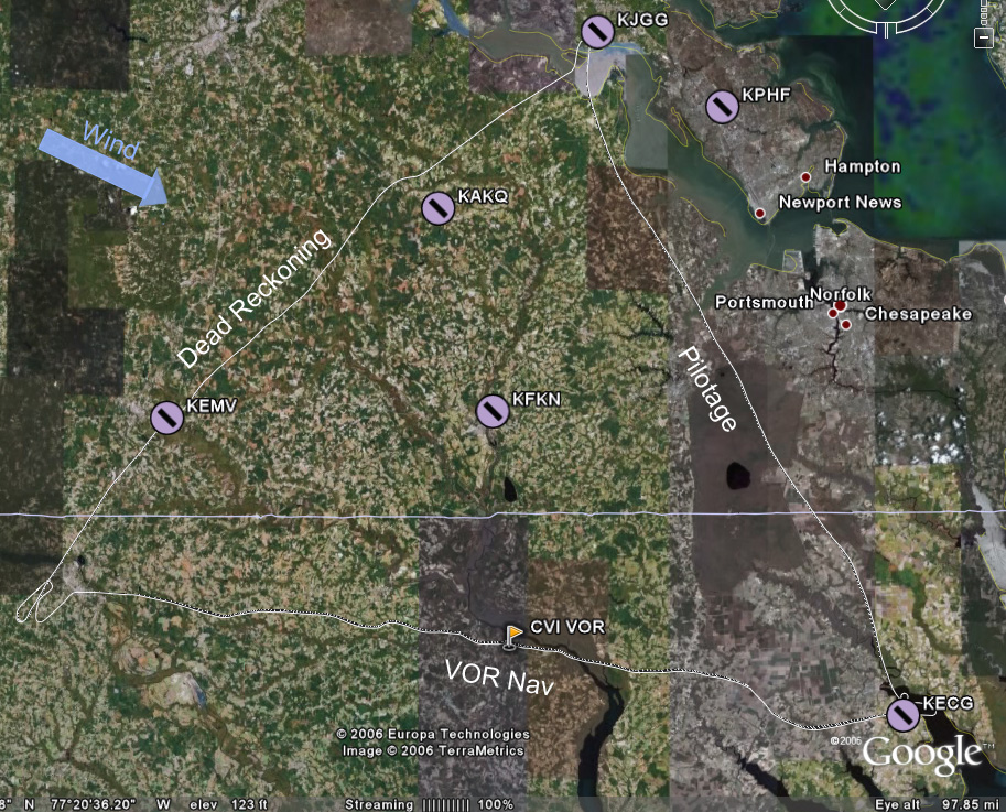
The plan was to go JGG to ECG by pilotage at 3500', opening the flight plan with Leesburg just after takeoff and talking to Norfolk Approach to pick up flight following. From ECG to RZZ would be a 4500' leg using the CVI VOR for navigation. Finally, from RZZ to JGG would be dead reckoning at 3500', using EMV and AKQ as checkpoints to break the ~65 nm leg into thirds.


We looked at the POH to get an idea of takeoff performance at our weight of ~2150 lbs. It would take longer than usual, but I didn't find it to be alarming or anything. We left from 31 and hooked around south, staying well west of the nuclear station. I called up Leesburg and opened the flight plan. My brief chat with him should have been much briefer, but it was my first time and the task was accomplished. Then I tried to get Norfolk on the air, and it took several tries, although the first try doesn't really count because I was still on the Leesburg frequency! Dumb! Eventually I did get him and we were in the system.

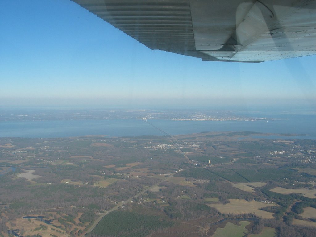
The James River Bridge (I think) crossing, duh, the James River!


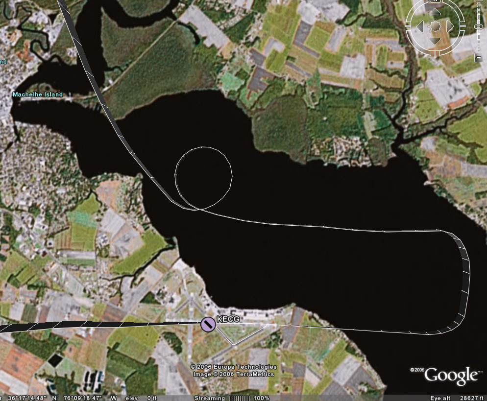
One of the landmarks for pilotage on this leg was Lake Drummond. From 3500' on a semi-hazy day, it's big enough and was catching the sun enough to look like a glowing disc in the middle of a gray-green swatch. Nice and easy to pick out. Just east of that lake was a long straight road with a long straight canal right next to it; another good landmark. We'd fly parallel to it for a short while, then we'd be able to see the inlet that, if followed, would lead us down to ECG. And indeed it did.

As we got close to ECG (which, by the way, is Elizabeth City Coast Guard station), we were handed off to the tower. A very good-natured guy answered, and I was happy to be interacting with such a positive personality for my first time into a towered field! He told us to set up for right traffic for 28 and to report midfield on downwind. I still had some altitude to lose, so Chuck suggested I tell him we wanted to do a 360 to bleed some off. He approved and said to report when reestablished in the pattern. You can see from the image of the track that we did that over the water, which was neat and a little disconcerting at the same time!

Anyway, we got back into the pattern and -- this was neat -- he said he'd tell me when to turn base. Well, ok then. I'd have to be a little more off-the-cuff with setting up to land, since the normal cues for putting out flaps or slowing down would be out of my control. It ended up being quite odd, though, because we had a very long downwind (extended well past the approach end of 28) before he told us to turn in. It was for the sake of ground operations: a jet and a 4-prop C130 were taxiing across the field. I reported to him when we were on final, and he cleared us to land. (Note: The GPS points say it was actually only a 2.5-mile final, but it seemed a lot longer than that! Final at JGG was less than 1 mile, and final at RZZ was a little over a mile.

And about an hour and a half we did! Just kidding, but that final was so long it seemed like we'd never get there. I had to power back up somewhat to keep from losing too much altitude along this stretch (so that 360 wouldn't have been necessary, had we known this was coming). But we made it to the runway and had a decent touchdown.

Mr. Nice Controller instructed me to turn off at taxiway Charlie, then hook a right and the FBO would be straight ahead. I replied that we'd like to taxi back and depart, and so he told us to take a left off taxiway Charlie instead and hold short for 28. I cleaned up the plane and took that left and followed a C130 to the hold short line, giving him (and his clouds of exhaust) puh-lenty of room. They took off and a short bit later we were cleared to depart straight out, which we did without event.

We compared landmarks to the sectional to decide when we were clear of his airspace and then I radioed to tell him that and thanks. He approved a frequency change and that was the end of that. I dialed in CVI, dialed in the 290 radial and then jockeyed around a little to get on it. The trip to it was uneventful as the flying goes, save for a little waddling around as I lost and then realigned the heading. Mentally, though, it was a little flustering. Chuck was asking me math questions, and I didn't think I was overloaded but I was having a hard time reasoning through. Eventually I started jotting things down on the kneeboard and was able to be more logical about it. It was stuff like "How long will it take us to get to RZZ?" That shouldn't be that hard -- I knew roughly where we were, could estimate from the highlighted path on the sectional how far we had to go, but for some reason when it came to figuring out how many minutes for that distance at our current ground speed (which the GPS gave me in knots), I just couldn't do it! I felt like a freakin moron and that was frustrating.

So I jotted down my little conversion factor -- ( 60 minutes/1 hour ) * ( 1 hour/98 nm ) * ( 42 nm left to go ) ---- so (60*42)/98. Riiiiight. I'm gonna do that in my head at the snap of the fingers. I was starting to multiply when Chuck changed it up and asked how many minutes it took to go one (nautical) mile.

If you have a dog, you know the dog reaction to something they just don't understand. Ears up, eyebrows up, head tilted to the side. That's how I felt.

Ok, minutes per mile. Back to the kneeboard. ( 60 minutes/1 hour ) * ( 1 hour/98 nm ) ---- so 60/98. So I previously had been figuring out just that conversion factor.... Ok, 60/98 is easily estimated to be around .67... So .67 minutes per mile, 42 miles left, 2/3 of 42 would be 28? Ok, 28 minutes to go.

Ugh. That was harder than it should have been. Looking at it, I think I would have been better off to think of 42/98 -- a little less than half -- and then take that portion of an hour.

So, whatever. I'll come back to this later.

A few minutes later another math problem: How far from the airport should we start our descent? Hmmm, oh, ok. We're at 4500', pattern altitude at the airport is ~1000'. So we've got 3500' to lose. Let's assume a nice gentle 500'/min descent. So we need 7 minutes. That one was easy enough.

Now what? What distance from the airport corresponds to 7 minutes? ( 98 nm / 1 hour ) * ( 1 hour / 60 minutes ) * 7 minutes ---- 98 * 7 / 60. I didn't get it in the air without some more leading questions from Chuck to break it down, but now when I look at it it seems easy -- 98/60 is roughly 1.5, time (round up to) 10 is 15. 15 miles out, plus a few miles to be near pattern altitude to check out the field and get settled in the environment. So at 18 miles out we'd start the descent.

Ok, fine. Except it didn't totally go like that. There was some other intermediate conversion factor in there, and I don't remember it specifically, but there was one on our final leg, so I'll think about it more in a few minutes...

The other thing that happened to fluster me a little was that during our discussion about how turbulent it was that day -- it was coming in waves where we'd have several minutes of nice calm air then several minutes of big bumps -- Chuck asked what we can do in the yellow arc on the airspeed indicator. The phrasing of the question threw me off. The yellow arc (on ours) goes from Vsse to Vne. I knew Vsse to be the "don't go faster than this in turbulent conditions" speed. But what can you do in that speed range? I don't know. The answer basically is that you can fly straight-and-level in the yellow arc. You don't want to stress the plane at those speeds, so you don't fly in that range when it's turbulent. You don't do maneuvers at those speeds.

When we started the descent, I was glad to be done with trying to maintain that radial from CVI to RZZ (again, you can see the squirreliness in the track). The sectional indicated that the airport was southwest of "stacks" on the edge of a town near the lake. I found the lake, found a town, and saw a plant of some sort that did have some vapor exhaust, so I started pointing to it, which was a little to the right of the nose. As we got closer, however, I realized that there was another town with two much taller stacks a little farther from the water. Consulting the sectional again showed that these taller stacks were the ones that led to the airport. I pointed back to the left a touch, and before long a nice clearing appeared with a long edge oriented the way we expected the runway to be. Sweet.

I called UNICOM, and a pleasant woman answered that we'd be using 23 and asked if she could get us a car or fuel or anything. Wasn't that nice? We wouldn't be needing anything, and so I swung wide to the southwest to get on a 45 for left downwind for 23. We had a decent, almost-perpendicular-to-the-runway crosswind at this point in the flight, and could see that the windsock down there was almost fully extended.

I started my usual pattern -- at 1000' for this airport -- abeam the numbers, and started to descend. I had overlooked that one little detail that this field's elevation is 200' higher than home, and for roughly equivalent pattern altitudes something would obviously need to change. Well, obvious to Chuck and obvious to me after he pointed it out. I powered up to stop the descent, and had also been planning on a higher airspeed over the threshold, so this was ok. As I turned final, directly into the blazing lowering sun, I was at ~500' over the field, had two notches of flaps out, and was doing the constant-correction technique. I crabbed a little, and then I decided to slip a little, and kept aligned with the right edge of the runway (the wind was from the right). I had another decent touchdown, but as I started to brake and the nose came down, the nosewheel started shimmying like it wanted to come off!

I pulled back on the yoke as far as I could with one hand, trying to get the weight shifted back to the main wheels and the shimmying to stop. Chuck hopped on to help me pull back farther, and it did stop. As we slowed and the nose rotated down, it started again. This time I jumped on it with both hands and got it under control myself. (On Wednesday (after this x-c which was on Tuesday), Husband met with the mechanic for a few different issues, and they pulled the nosewheel shimmy dampener and found that the seals had dried out and there was no hydraulic fluid left. Mechanic was supposed to fix it that day, I think.)

We taxiied back to the approach end of 23 (which I incorrectly and generically called the end of 5) and took off into that inconveniently located sun. We departed and rose to ~1200' before turning off to the left and following the pattern as we continued to climb. As we left the airport I checked my nav log for the DR "settings" for the first checkpoint and set us up. We headed out and continued climbing to 3500'.

I really fought to keep on the heading for this exercise, knowing that being off by a degree would have a bigger impact the farther I went. Granted, each checkpoint was only 16-18 miles apart, but still... Much to my astonishment, we were dead on for EMV as far as heading goes, and were only about 20 seconds late in getting there. (Since RTFP doesn't build in time for the climb out of RZZ, that seemed pretty good o me.) Enthused, I reconfigured us for the next checkpoint.

This time, I was bad. We were on course and I was holding the heading pretty well. I even had it trimmed well enough that when Chuck said to let the plane fly itself (no autopilot, remember), it held 3500 nicely and except for the occasional bobble from the wind it stayed true. What was bad, though, is that as the time for AKQ was drawing near, I started cheating. AKQ is hard to find, and if we weren't dead on I wanted to be prepared for whatever correction would be needed. The only thing that helps to find it from 10 miles out is that it's just north of a little town in the middle of woods and farmland. I saw a town, and I even thought I could make out the white radar dome. So I nudged our nose just slightly to the left to point us toward the town. That was bad, and I learned my lesson. My eyes fooled me, and that wasn't the right town. As we got even closer, I couldn't find a runway, so I glanced down at the GPS -- we were several miles west of the airport! In looking at the GPS track above, you can see where I nudged left going up to AKQ, and how if I had just stayed the course we would have been really close.

From there I could see the curves in the river that cradle JGG so we just went by pilotage the rest of the way. Somewhere along this last jaunt we talked about how next time we'll use the E6B wind wheel to make adjustments on the fly (ha ha ha, that pun never gets old), and then came the last piece of math.

The part of this math that stands out in my mind was that 102 - 60 is 42 and 42/6 is 7 so we have 1.7 of something... minutes or miles and where did that 6 come from? 102 was our groundspeed at the time, so that would be 1.7 miles per minute. I've tried that with a few other numbers and it's a math trick -- find an even number of times it'll divide (in our case 1, but think about something like 330/50, where it would be 6). Take the remainder (42 or 30) and divide by the original divisor divided by 10 (6 or 5), then put it together with a decimal and you'll get your answer (1.7 or 6.6). Ah, yes, introducing the decimal justifies dividing by 10. This obviously works nicely for divisors that are multiples of 10. Now why were we figuring that out? Oh, well, if we were deciding when to descend, we'd know how long it would require to get down, so this factor would tell us how far from the airport we'd need to be when we started the descent.

The landing at JGG was normal with the exception of another nosewheel shimmy. I was nowhere near as tired as I expected to be.

(Don't make fun of my gum-chewing! It helps me to fly better, I swear! And you can see just how bad the sun was at RZZ.)

Discussion:
  1. ATC, approach, etc: I haven't really figured out the flow for these interactions yet. What helped me to get a grip of the various emergency procedures was to understand the flow -- for instance, in flight engine loss goes preserve altitude, figure out where to go, try to restart, communicate, shutdown. That's a logical sequence of events, and each of those items has a set of tasks associated with it.

    I figure there'll be some nice flow for talking to ATC. Something like hail them, give location and intention, respond as appropriate. But when talking to approach maybe it's different, more like hail them, give intention, respond as required. Getting an understanding of that will make it easier to fill in the details. And with experience hopefully it won't seem like a random and blubbery chat every time....

  2. Dead reckoning: So this is the kind of navigation that I've talked about with Husband and said repeatedly that I just don't see how it could work. It seems like there are so many factors, and so many things that could change between when you do your calculations and two hours later when you get in the air and two hours after that when you get to the later checkpoints. But I'll be damned if RZZ to EMV wasn't perfect empirical evidence that it does in fact work. And I'll also be damned if EMV to AKQ wasn't perfect empirical evidence of screwing up what would have worked by thinking I knew better than the calculations. I mean, you've gotta be heads-up and flexible and ready to adjust your plan, right? But I misjudged and proved that changing the plan without a good solid indisputable reason produced the wrong results.

  3. Math: I'm an engineer. I don't hate math. I assume that (1) just like the whole can't-do-math thing from one of the first lessons, after I'm used to the various things that are going on during a cross-country it'll come easier and (2) after I've done those kinds of calculations a few more times and am familiar with what I'm trying to determine and how best to get it it'll come easier.

    The workload thing (#1) is a cop-out explanation, though, since it wasn't like I had to do math while listening to a controller or something; the math came at times when it was just normal flight.

  4. Husband: Husband said he was proud of me and my progress and he'll have no problem whatsoever letting me do everything on the next trip. The previous trips I've done everything in-flight, but no takeoffs or landings. Plus, next Monday he's going to do his BFR with Chuck, and do it from the right seat.

  5. Tracking a heading: My goodness. When we were in the air, I knew I was doing a little meandering and realigning on the heading, but I didn't think it was nearly as bad as what the GPS track shows! Is that amount of divergence normal, or a sign of inexperience, or a sign of too little focus on heading, or what? On the one hand, I'm being pretty hard on myself about being sloppy, but on the other hand, I'd have had to spend twice as much time looking at the heading indicator and cross-checking the mag compass for accuracy to have stuck it better. I'm guessing there's a reasonable balance there. I also wonder whether a less turbulent day would have made a difference -- there was a sigmet for moderate turbulence, and the ECG-RZZ leg did have a fair amount of bumps, but does turbulence affect the heading-tracking ability much?


Self-Assessment: More polish, more practice, especially on the com!
    Flying
  • Preflight, taxiing, normal takeoff, short-field takeoff: Good.
  • Soft-field takeoff: Needs practice.
  • Maintaining airspeed, stalls, slow flight (VR/IR), maintain/change attitude/altitude/heading by instruments: Good.
  • Recover attitude, altitude, heading by instruments: Acceptable.
  • Forced landing: Good, need more practice.
  • Forward slip:: Dunno, needs more practice.
  • Pattern, normal landing, directional control after landing: Good.
  • Crosswind landing: Decent.
  • Radio work: Untowered, good; everything else, needs focused practice!
  • Short-field landing: Improved.
  • Soft-field landing: Not sure...
    Navigating
  • ADF: Okay for an intro, needs practice.
  • VOR: Use of is good; tracking the heading needs refinement.
  • Dead reckoning: Gotta trust the numbers! Also we'll practice adjusting the numbers in-flight for differing circumstances next time.

Next: I've got the plane Monday afternoon for another x-c, assuming Chuck is up for it after Husband's BFR.
  • More cross-country planning (with just-prior wind calcs!).
  • Short cross-country trip.
Hours logged this flight: 3.0
Hours logged total: 29.8
Instrument hours logged this lesson: 0.0
Instrument Hours logged total: 1.6
Take-offs and landings this flight: 3
Take-offs and landings total: 80
PIC hours total:: 5.7